|
|
Antenna Structure Registration 1021056 |
 |
Registration Info | Registration Number: 1021056 |
| File Number: A1231391 |
| FAA Study: 2021-AWP-19155-OE |
| FAA Issue Date: 11/09/2022 |
| Status: Constructed |
| Date Constructed: 08/07/2001 |
| NEPA: N |
Structure Info
| Structure Type: GTOWER |
| Structure Coordinates: 38-42-28.1 N 121-28-36.3 W (NAD 83) |
| Structure Coordinates: 38-42-28.5 N 121-28-32.5 W (Converted to NAD 27) |
| Structure Address: 606 West Delano St (elverta #8730) |
| Structure City: Elverta, CA |
| Structure County: Sacramento County |
| Painting & Lighting Info |
FAA Circular #: 70/7460-1K |
FAA Chapters: 3, 4, 5, 12 |
Remarks: PRIOR STUDY 2012-AWP-8909-OE |
Remarks: OM&L to remain the same as prior study = PAINT/RED LIGHTS |
Remarks: PRIOR STUDY 2012-AWP-8909-OE |
Remarks: OM&L to remain the same as prior study = PAINT/RED LIGHTS |
| Elevation Info |
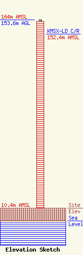
Site Elevation: 10.4 meters (34 ft) |
| Height of Structure: 152.4 meters (500 feet) |
| Overall Height Above Ground: 153.6 meters (504 feet) |
| Overall Height Above Mean Sea Level: 164 meters (538 feet) |
| KMSX-LD C/R Height Above Mean Sea Level: 152.4 meters (500 ft)
|
| Owner Info | American Towers LLC
10 Presidential Way
Woburn, MA 01801
(781) 926-4500
faa-fcc@americantower.com |
| Contact Info | American Towers LLC
10 Presidential Way
Woburn, MA 01801
(781) 926-4500
faa-fcc@americantower.com |
