|
|
Antenna Structure Registration 1021057 |
 |
Registration Info | Registration Number: 1021057 |
| File Number: A1273934 |
| FAA Study: 2004-AWP-2450-OE |
| FAA Issue Date: 07/22/2004 |
| Status: Constructed |
| Date Constructed: 01/01/1960 |
| FAA EMI: N |
| NEPA: N |
Structure Info
| Structure Type: TOWER |
| Structure Coordinates: 38-33-58.9 N 121-28-50.4 W (NAD 83) |
| Structure Coordinates: 38-33-59.2 N 121-28-46.6 W (Converted to NAD 27) |
| Structure Address: 1811 22nd Street (atc# 8731) |
| Structure City: Sacramento, CA |
| Structure County: Sacramento County |
| Painting & Lighting Info |
FAA Circular #: 70/7460-1J |
FAA Chapters: 3, 4, 5, 13 |
Remarks: PRIOR STUDY 2001-AWP-1222-OE |
Remarks: OM&L to remain the same as prior study = PAINT/RED LIGHTS |
Remarks: PRIOR STUDY 2001-AWP-1222-OE |
Remarks: OM&L to remain the same as prior study = PAINT/RED LIGHTS |
| Elevation Info |
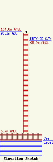
Site Elevation: 6.7 meters (22 ft) |
| Height of Structure: 96.3 meters (316 feet) |
| Overall Height Above Ground: 98.1 meters (322 feet) |
| Overall Height Above Mean Sea Level: 104.8 meters (344 feet) |
| KBTV-CD C/R Height Above Mean Sea Level: 95.9 meters (315 ft)
|
| Owner Info | SWI Funds Tower Holdings, LLC
57 E Washington St
Chagrin Falls, OH 44022
(440) 528-0333
rlepene@k2towers.com |
| Contact Info | K2 Towers III, LLC
57 E Washington Street
Chagrin Falls, OH 44022
Greg Thompson
(440) 528-0333
gthompson@k2towers.com |
