|
|
Antenna Structure Registration 1023288 |
 |
Registration Info | Registration Number: 1023288 |
| File Number: A0842717 |
| FAA Study: 87-AGL-143-OE3 |
| FAA Issue Date: 06/25/1987 |
| Status: Constructed |
| Date Constructed: 09/18/1989 |
| FAA EMI: N |
| NEPA: N |
Structure Info
| Structure Type: 4TA3 |
| Structure Coordinates: 44-59-20.8 N 92-58-54.0 W (NAD 83) |
| Structure Coordinates: 44-59-20.9 N 92-58-53.2 W (Converted to NAD 27) |
| Structure Address: Twr 3 2754 Geneva Ave |
| Structure City: Oakdale, MN |
| Structure County: Washington County |
| Painting & Lighting Info |
FAA Circular #: 70/7460-1G |
FAA Chapters: 3, 4, 5, 9 |
| Elevation Info |
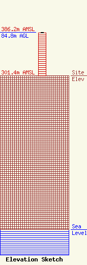
Site Elevation: 301.4 meters (989 ft) |
| Height of Structure: 83.9 meters (275 feet) |
| Overall Height Above Ground: 84.8 meters (278 feet) |
| Overall Height Above Mean Sea Level: 386.2 meters (1267 feet) |
| Owner Info | UNIVERSITY OF NORTHWESTERN - ST PAUL
3003 SNELLING AVE N
ROSEVILLE, MN 55113
(651) 631-5009
sajones@unwsp.edu |
| Info |
