|
|
Antenna Structure Registration 1023423 |
 |
Registration Info | Registration Number: 1023423 |
| File Number: A1213843 |
| FAA Study: 2015-ANM-299-OE |
| FAA Issue Date: 04/02/2015 |
| Status: Constructed |
| Date Constructed: 01/01/1973 |
| NEPA: N |
Structure Info
| Structure Type: GTOWER |
| Structure Coordinates: 39-43-44.1 N 105-14-10.0 W (NAD 83) |
| Structure Coordinates: 39-43-44.1 N 105-14-08.0 W (Converted to NAD 27) |
| Structure Address: On Lookout Mountain 3.2 Km Sw |
| Structure City: Golden, CO |
| Structure County: Jefferson County |
| Painting & Lighting Info |
FAA Chapters: NONE |
| Elevation Info |
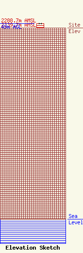
Site Elevation: 2239.7 meters (7348 ft) |
| Height of Structure: 49 meters (161 feet) |
| Overall Height Above Ground: 49 meters (161 feet) |
| Overall Height Above Mean Sea Level: 2288.7 meters (7509 feet) |
| Owner Info | VB-S1 Assets, LLC
750 Park of Commerce Dr.
Boca Raton, FL 33487
(561) 406-4015
FCCSecuritization@verticalbridge.com |
| Contact Info | VB-S1 Assets, LLC
750 Park of Commerce Dr.
Boca Raton, FL 33487
Richard Hickey
(561) 406-4015
FCCSecuritization@verticalbridge.com |
