|
|
Antenna Structure Registration 1026276 |
 |
Registration Info | Registration Number: 1026276 |
| File Number: A1275373 |
| FAA Study: 2022-AEA-7071-OE |
| FAA Issue Date: 06/02/2023 |
| Status: Constructed |
| Date Constructed: 02/17/1966 |
| NEPA: N |
Structure Info
| Structure Type: LTOWER |
| Structure Coordinates: 40-27-19.2 N 74-17-42.5 W (NAD 83) |
| Structure Coordinates: 40-27-18.8 N 74-17-44.0 W (Converted to NAD 27) |
| Structure Address: 491 Ernston Road (88099) |
| Structure City: Parlin, NJ |
| Structure County: Middlesex County |
| Painting & Lighting Info |
FAA Circular #: 70/7460-1K |
FAA Chapters: 4, 8, 12 |
Remarks: PRIOR STUDY 2009-AEA-2389-OE |
Remarks: OM&L to remain the same as prior study = A MED-DUAL SYSTEM |
Remarks: PRIOR STUDY 2009-AEA-2389-OE |
Remarks: OM&L to remain the same as prior study = A MED-DUAL SYSTEM |
| Elevation Info |
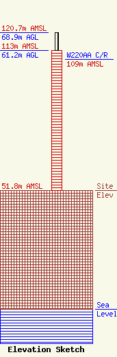
Site Elevation: 51.8 meters (170 ft) |
| Height of Structure: 61.2 meters (201 feet) |
| Overall Height Above Ground: 68.9 meters (226 feet) |
| Overall Height Above Mean Sea Level: 120.7 meters (396 feet) |
| W220AA C/R Height Above Mean Sea Level: 109 meters (358 ft)
|
| Owner Info | American Towers LLC
10 Presidential Way
Woburn, MA 01801
(781) 926-4500
faa-fcc@americantower.com |
| Contact Info | American Towers LLC
10 Presidential Way
Woburn, MA 01801
(781) 926-4500
faa-fcc@americantower.com |
