|
|
Antenna Structure Registration 1030093 |
 |
Registration Info | Registration Number: 1030093 |
| File Number: A0635166 |
| FAA Study: 91-AGL-1656-OE |
| FAA Issue Date: 12/09/1991 |
| Status: Constructed |
| Date Constructed: 06/01/1992 |
| FAA EMI: N |
| NEPA: N |
Structure Info
| Structure Type: TOWER |
| Structure Coordinates: 40-31-20.0 N 86-58-57.0 W (NAD 83) |
| Structure Coordinates: 40-31-19.9 N 86-58-57.0 W (Converted to NAD 27) |
| Structure Address: .5 Km S Int 750n & 400w |
| Structure City: West Lafayette, IN |
| Structure County: Tippecanoe County |
| Painting & Lighting Info |
FAA Circular #: 70/7460-1H |
FAA Chapters: 3, 4, 5, 13 |
| Elevation Info |
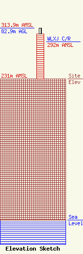
Site Elevation: 231 meters (758 ft) |
| Height of Structure: 73.7 meters (242 feet) |
| Overall Height Above Ground: 82.9 meters (272 feet) |
| Overall Height Above Mean Sea Level: 313.9 meters (1030 feet) |
| WLXJ C/R Height Above Mean Sea Level: 292 meters (958 ft)
|
| Owner Info | Educational Media Foundation
5700 West Oaks Blvd
Rocklin, CA 95765
(916) 251-1700
|
| Contact Info | Educational Media foundation
5700 West Oaks Blvd.
Rocklin, CA 95765
Joe Miller
(916) 251-1700
|
