|
|
Antenna Structure Registration 1033447 |
 |
Registration Info | Registration Number: 1033447 |
| File Number: A1289565 |
| FAA Study: 2022-AEA-9713-OE |
| FAA Issue Date: 06/06/2023 |
| Status: Constructed |
| Date Constructed: 09/05/1989 |
| NEPA: N |
Structure Info
| Structure Type: LTOWER |
| Structure Coordinates: 38-25-10.4 N 82-24-5.3 W (NAD 83) |
| Structure Coordinates: 38-25-10.1 N 82-24-05.8 W (Converted to NAD 27) |
| Structure Address: 2881 Reservoir Rd (099388) |
| Structure City: Huntington, WV |
| Structure County: Cabell County |
| Painting & Lighting Info |
FAA Circular #: 70/7460-1K |
FAA Chapters: 4, 8, 12 |
Remarks: OM&L to remain the same as prior study = A MED-DUAL SYSTEM |
Remarks: PRIOR STUDY 2007-AEA-3882-OE |
Remarks: OM&L to remain the same as prior study = A MED-DUAL SYSTEM |
Remarks: PRIOR STUDY 2007-AEA-3882-OE |
| Elevation Info |
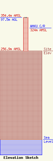
Site Elevation: 256.9 meters (843 ft) |
| Height of Structure: 97.5 meters (320 feet) |
| Overall Height Above Ground: 97.5 meters (320 feet) |
| Overall Height Above Mean Sea Level: 354.4 meters (1163 feet) |
| WHKU C/R Height Above Mean Sea Level: 324 meters (1063 ft)
|
| Owner Info | American Towers LLC
10 Presidential Way
Woburn, MA 01801
(781) 926-4500
faa-fcc@americantower.com |
| Contact Info | American Towers LLC
10 Presidential Way
Woburn, MA 01801
(781) 926-4500
faa-fcc@americantower.com |
