|
|
Antenna Structure Registration 1034158 |
 |
Registration Info | Registration Number: 1034158 |
| File Number: A1233150 |
| FAA Study: 86-AEA-1094-OE |
| Status: Constructed |
| Date Constructed: 01/01/1987 |
| FAA EMI: N |
| NEPA: N |
Structure Info
| Structure Type: TOWER |
| Structure Coordinates: 38-24-18.0 N 75-36-2.0 W (NAD 83) |
| Structure Coordinates: 38-24-17.6 N 75-36-03.3 W (Converted to NAD 27) |
| Structure Address: 7757 Jersey Road |
| Structure City: Salisbury, MD |
| Structure County: Wicomico County |
| Painting & Lighting Info |
FAA Circular #: 70/7460-1G |
FAA Chapters: 3, 4, 5, 9 |
| Elevation Info |
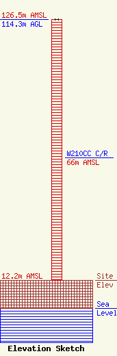
Site Elevation: 12.2 meters (40 ft) |
| Height of Structure: 114.3 meters (375 feet) |
| Overall Height Above Ground: 114.3 meters (375 feet) |
| Overall Height Above Mean Sea Level: 126.5 meters (415 feet) |
| W210CC C/R Height Above Mean Sea Level: 66 meters (217 ft)
|
| Owner Info | CTI Towers Assets II, LLC
3300 Paramount Parkway
27560
Morrisville, NC 27560
(919) 655-7831
ccooper@ctitowers.com |
| Contact Info | CTI Towers Assets II, LLC
3300 Paramount Parkway
27560
Morrisville, NC 27560
Christine Cooper
(919) 655-7831
ccooper@ctitowers.com |
