|
|
Antenna Structure Registration 1035330 |
 |
Registration Info | Registration Number: 1035330 |
| File Number: A0453030 |
| FAA Study: 97-AGL-4906-OE |
| FAA Issue Date: 11/13/1997 |
| Status: Constructed |
| Date Constructed: 07/10/1991 |
| FAA EMI: N |
| NEPA: N |
Structure Info
| Structure Type: 3TA1 |
| Structure Coordinates: 42-54-46.0 N 97-18-59.0 W (NAD 83) |
| Structure Coordinates: 42-54-46.0 N 97-18-57.8 W (Converted to NAD 27) |
| Structure Address: Twr 1 5 Miles Northeast |
| Structure City: Yankton, SD |
| Structure County: Yankton County |
| Painting & Lighting Info |
FAA Circular #: 70/7460-1J |
FAA Chapters: 3, 4, 5, 13 |
| Elevation Info |
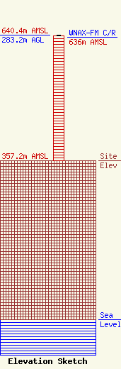
Site Elevation: 357.2 meters (1172 ft) |
| Height of Structure: 282.4 meters (927 feet) |
| Overall Height Above Ground: 283.2 meters (929 feet) |
| Overall Height Above Mean Sea Level: 640.4 meters (2101 feet) |
| WNAX-FM C/R Height Above Mean Sea Level: 636 meters (2087 ft)
|
| Owner Info | Saga Communications, Inc.
73 Kercheval Avenue, Suite 201
Grosse Pointe Farms, MI 48236
(313) 886-7070
gurbiel@sagacom.com |
| Contact Info | Smithwick & Belendiuk, P.C.
5028 Wisconsin Avenue, NW Suite 301
Washington, DC 20016
Gary Smithwick
(202) 363-4050
gsmithwick@fccworld.com |
