|
|
Antenna Structure Registration 1036252 |
 |
Registration Info | Registration Number: 1036252 |
| File Number: A1054355 |
| FAA Study: 2016-ACE-2279-OE |
| FAA Issue Date: 11/22/2016 |
| Status: Constructed |
| Date Constructed: 12/01/1993 |
| NEPA: N |
Structure Info
| Structure Type: GTOWER |
| Structure Coordinates: 38-56-7.5 N 94-50-42.1 W (NAD 83) |
| Structure Coordinates: 38-56-07.5 N 94-50-41.2 W (Converted to NAD 27) |
| Structure Address: 10650 Lone Elm |
| Structure City: Olathe, KS |
| Structure County: Johnson County |
| Painting & Lighting Info |
FAA Circular #: 70/7460-1K |
FAA Chapters: 3, 4, 5, 12 |
Remarks: OM&L to remain the same as prior study = PAINT/RED LIGHTS |
Remarks: PRIOR STUDY 2013-ACE-9-OE |
Remarks: OM&L to remain the same as prior study = PAINT/RED LIGHTS |
Remarks: PRIOR STUDY 2013-ACE-9-OE |
| Elevation Info |
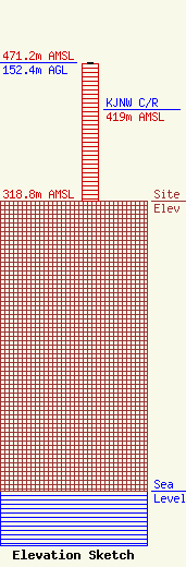
Site Elevation: 318.8 meters (1046 ft) |
| Height of Structure: 151.5 meters (497 feet) |
| Overall Height Above Ground: 152.4 meters (500 feet) |
| Overall Height Above Mean Sea Level: 471.2 meters (1546 feet) |
| KJNW C/R Height Above Mean Sea Level: 419 meters (1375 ft)
|
| Owner Info | BOTT BROADCASTING COMPANY
10550 BARKLEY
OVERLAND PARK, KS 66212
(913) 642-7770
efowler@bottradionetwork.com |
| Contact Info | Bott Broadcasting Company
10550 Barkley
Overland Park, KS 66212
(913) 642-7770
efowler@bottradionetwork.com |
