|
|
Antenna Structure Registration 1038231 |
 |
Registration Info | Registration Number: 1038231 |
| File Number: A1194761 |
| FAA Study: 97-ANE-879-OE |
| FAA Issue Date: 03/19/1998 |
| Status: Constructed |
| Date Constructed: 01/01/1980 |
| FAA EMI: N |
| NEPA: N |
Structure Info
| Structure Type: TOWER |
| Structure Coordinates: 41-52-14.0 N 71-17-43.0 W (NAD 83) |
| Structure Coordinates: 41-52-13.6 N 71-17-44.8 W (Converted to NAD 27) |
| Structure Address: 33 Pine St |
| Structure City: Rehoboth, MA |
| Structure County: Bristol County |
| Painting & Lighting Info |
FAA Circular #: 70/7460-1J |
FAA Chapters: 3, 4, 5, 13 |
Remarks: Removed expiration and final dates from determination. Scenario 2./jjs/case#635066 |
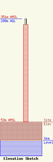
| Elevation Info |
Site Elevation: 53 meters (174 ft) |
| Height of Structure: 281.4 meters (923 feet) |
| Overall Height Above Ground: 298 meters (978 feet) |
| Overall Height Above Mean Sea Level: 351 meters (1152 feet) |
| Owner Info | Nexstar Media Inc.
545 E. John Carpenter Freeway
Irving, TX 75062
(972) 373-8800
jasroberts@nexstar.tv |
| Contact Info | Nexstar Media Inc.
545 E. John Carpenter Freeway
Irving, TX 75062
Jason Roberts
(972) 373-8800
jasroberts@nexstar.tv |
