|
|
Antenna Structure Registration 1044434 |
 |
Registration Info | Registration Number: 1044434 |
| File Number: A0052440 |
| FAA Study: MKC-OE-68-257 |
| FAA Issue Date: 04/24/1968 |
| Status: Constructed |
| Date Constructed: 10/01/1971 |
| NEPA: N |
Structure Info
| Structure Type: TOWER |
| Structure Coordinates: 39-6-50.0 N 94-40-46.0 W (NAD 83) |
| Structure Coordinates: 39-06-50.0 N 94-40-45.1 W (Converted to NAD 27) |
| Structure Address: 4121 Minnesota Ave |
| Structure City: Kansas City, KS |
| Structure County: Wyandotte County |
| Painting & Lighting Info |
FCC Paragraph(s): 1, 3, 4, 13, 21 |
Remarks: RED LIGHTS/PAINT |
| Elevation Info |
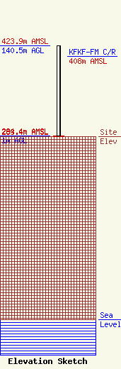
Site Elevation: 283.4 meters (930 ft) |
| Height of Structure: 1 meters (3 feet) |
| Overall Height Above Ground: 140.5 meters (461 feet) |
| Overall Height Above Mean Sea Level: 423.9 meters (1391 feet) |
| KFKF-FM C/R Height Above Mean Sea Level: 408 meters (1339 ft)
|
| Owner Info | KCBR-AM LIMITED PARTNERSHIP DBA = RADIO STATION KCBR
4121 MINNESOTA AVE.
KANSAS CITY, KS 66102
(913) 342-1600
|
