|
|
Antenna Structure Registration 1044528 |
 |
Registration Info | Registration Number: 1044528 |
| File Number: A1223084 |
| FAA Study: 97-ACE-1741-OE |
| Status: Granted |
| FAA EMI: N |
| NEPA: N |
Structure Info
| Structure Type: TOWER |
| Structure Coordinates: 39-0-45.0 N 95-1-47.0 W (NAD 83) |
| Structure Coordinates: 39-00-45.0 N 95-01-46.1 W (Converted to NAD 27) |
| Structure Address: 1.5 Km Ne |
| Structure City: Linwood, KS |
| Structure County: Leavenworth County |
| Painting & Lighting Info |
FAA Circular #: 70/7460-1H |
FAA Chapters: 4, 7, 13 |
| Elevation Info |
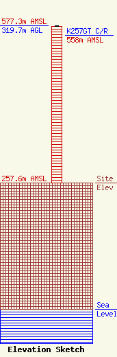
Site Elevation: 257.6 meters (845 ft) |
| Height of Structure: 318.5 meters (1045 feet) |
| Overall Height Above Ground: 319.7 meters (1049 feet) |
| Overall Height Above Mean Sea Level: 577.3 meters (1894 feet) |
| K257GT C/R Height Above Mean Sea Level: 558 meters (1831 ft)
|
| Owner Info | Diamond Towers IV LLC
210 Mountain Ave.
Springfield, NJ 07081
(262) 649-4429
sberry@diamondcomm.com |
| Contact Info | Diamond Towers IV LLC
210 Mountain Ave.
Springfield, NJ 07081
(262) 649-4429
sberry@diamondcomm.com |
