|
|
Antenna Structure Registration 1044854 |
 |
Registration Info | Registration Number: 1044854 |
| File Number: A0052906 |
| FAA Study: 87-AEA-0568-OE |
| FAA Issue Date: 10/23/1962 |
| Status: Constructed |
| Date Constructed: 01/01/1963 |
| NEPA: N |
Structure Info
| Structure Type: TOWER |
| Structure Coordinates: 41-44-46.0 N 73-54-44.0 W (NAD 83) |
| Structure Coordinates: 41-44-45.7 N 73-54-45.5 W (Converted to NAD 27) |
| Structure Address: End Of W View Dr |
| Structure City: Hyde Park, NY |
| Structure County: Dutchess County |
| Painting & Lighting Info |
FCC Paragraph(s): 1, 3, 11, 21 |
Remarks: RED LIGHTS/PAINT |
| Elevation Info |
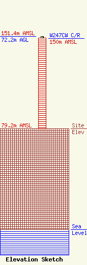
Site Elevation: 79.2 meters (260 ft) |
| Height of Structure: 71 meters (233 feet) |
| Overall Height Above Ground: 72.2 meters (237 feet) |
| Overall Height Above Mean Sea Level: 151.4 meters (497 feet) |
| W247CW C/R Height Above Mean Sea Level: 150 meters (492 ft)
|
| Owner Info | FERRARO, JOSEPH PAUL
316 MAIN MALL
POUGHKEEPSIE, NY 12601
(914) 471-9500
WHVW@MHVNET |
