|
|
Antenna Structure Registration 1044879 |
 |
Registration Info | Registration Number: 1044879 |
| File Number: A0932458 |
| FAA Study: 2014-AEA-6727-OE |
| FAA Issue Date: 10/23/2014 |
| Status: Constructed |
| Date Constructed: 05/31/2003 |
| NEPA: N |
Structure Info
| Structure Type: LTOWER |
| Structure Coordinates: 40-47-17.4 N 74-15-17.5 W (NAD 83) |
| Structure Coordinates: 40-47-17.0 N 74-15-19.0 W (Converted to NAD 27) |
| Structure Address: 12-16 Marcella Ave(282671) |
| Structure City: West Orange, NJ |
| Structure County: Essex County |
| Painting & Lighting Info |
FAA Circular #: 70/7460-1K |
FAA Chapters: 4, 6, 12 |
Remarks: PRIOR STUDY 2007-AEA-2741-OE |
| Elevation Info |
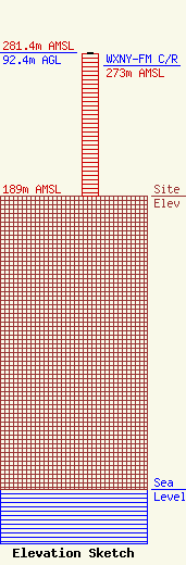
Site Elevation: 189 meters (620 ft) |
| Height of Structure: 91.4 meters (300 feet) |
| Overall Height Above Ground: 92.4 meters (303 feet) |
| Overall Height Above Mean Sea Level: 281.4 meters (923 feet) |
| WXNY-FM C/R Height Above Mean Sea Level: 273 meters (896 ft)
|
| Owner Info | American Towers LLC
10 Presidential Way
Woburn, MA 01801
(678) 564-3236
FAA-FCC@americantower.com |
| Contact Info | American Tower, LLC
10 Presidential Way
Woburn, MA 01801
(678) 564-3236
FAA-FCC@americantower.com |
