|
|
Antenna Structure Registration 1045848 |
 |
Registration Info | Registration Number: 1045848 |
| File Number: A0916117 |
| FAA Study: 2014-AEA-4388-OE |
| FAA Issue Date: 07/28/2014 |
| Status: Constructed |
| Date Constructed: 05/03/2004 |
| FAA EMI: N |
| NEPA: N |
Structure Info
| Structure Type: GTOWER |
| Structure Coordinates: 40-31-45.5 N 74-23-32.3 W (NAD 83) |
| Structure Coordinates: 40-31-45.1 N 74-23-33.8 W (Converted to NAD 27) |
| Structure Address: 80 Talmadge Road (000054 /edison Nj) |
| Structure City: Edison, NJ |
| Structure County: Middlesex County |
| Painting & Lighting Info |
FAA Circular #: 70/7460-1K |
FAA Chapters: 4, 8, 12 |
Remarks: PRIOR STUDY 2013-AEA-5523-OE |
| Elevation Info |
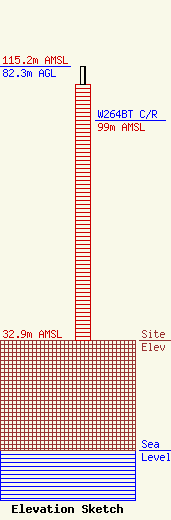
Site Elevation: 32.9 meters (108 ft) |
| Height of Structure: 76.8 meters (252 feet) |
| Overall Height Above Ground: 82.3 meters (270 feet) |
| Overall Height Above Mean Sea Level: 115.2 meters (378 feet) |
| W264BT C/R Height Above Mean Sea Level: 99 meters (325 ft)
|
| Owner Info | American Towers LLC
10 Presidential Way
Woburn, MA 01801
(678) 564-3236
faa-fcc@americantower.com |
| Contact Info | American Towers, LLC.
10 Presidential Way
Woburn, MA 01801
(678) 564-3236
faa-fcc@americantower.com |
