|
|
Antenna Structure Registration 1046926 |
 |
Registration Info | Registration Number: 1046926 |
| File Number: A1182103 |
| FAA Study: 2011-ANE-1829-OE |
| FAA Issue Date: 10/25/2011 |
| Status: Constructed |
| Date Constructed: 01/01/1986 |
| NEPA: N |
Structure Info
| Structure Type: GTOWER |
| Structure Coordinates: 41-21-43.3 N 73-6-46.4 W (NAD 83) |
| Structure Coordinates: 41-21-43.0 N 73-06-48.0 W (Converted to NAD 27) |
| Structure Address: 80 Great Hill Road |
| Structure City: Seymour, CT |
| Structure County: New Haven County |
| Painting & Lighting Info |
FAA Circular #: 70/7460-1K |
FAA Chapters: 4, 8, 12 |
Remarks: PRIOR STUDY 2006-ANE-114-OE |
| Elevation Info |
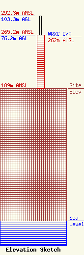
Site Elevation: 189 meters (620 ft) |
| Height of Structure: 76.2 meters (250 feet) |
| Overall Height Above Ground: 103.3 meters (339 feet) |
| Overall Height Above Mean Sea Level: 292.3 meters (959 feet) |
| WRXC C/R Height Above Mean Sea Level: 262 meters (860 ft)
|
| Owner Info | American Towers LLC
10 Presidential Way
Woburn, MA 01801
(781) 926-4500
faa-fcc@americantower.com |
| Contact Info | American Towers LLC
10 Presidential Way
Woburn, MA 01801
(781) 926-4500
faa-fcc@americantower.com |
