|
|
Antenna Structure Registration 1046972 |
 |
Registration Info | Registration Number: 1046972 |
| File Number: A0507744 |
| FAA Study: 2006-AEA-1414-OE |
| FAA Issue Date: 04/17/2006 |
| Status: Constructed |
| Date Constructed: 06/01/2006 |
| FAA EMI: N |
| NEPA: N |
Structure Info
| Structure Type: TOWER |
| Structure Coordinates: 40-53-14.0 N 74-41-54.0 W (NAD 83) |
| Structure Coordinates: 40-53-13.6 N 74-41-55.4 W (Converted to NAD 27) |
| Structure Address: Nj State Police Rt 206 & Rt 80 |
| Structure City: Netcong, NJ |
| Structure County: Morris County |
| Painting & Lighting Info |
FAA Circular #: 70/7460-1K |
FAA Chapters: 4, 6, 12 |
Remarks: PRIOR STUDY 1998-AEA-2287-OE |
| Elevation Info |
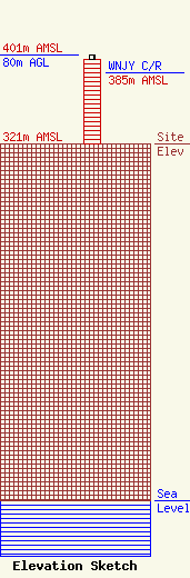
Site Elevation: 321 meters (1053 ft) |
| Height of Structure: 76 meters (249 feet) |
| Overall Height Above Ground: 80 meters (262 feet) |
| Overall Height Above Mean Sea Level: 401 meters (1316 feet) |
| WNJY C/R Height Above Mean Sea Level: 385 meters (1263 ft)
|
| Owner Info | NEW JERSEY, STATE OF
7068
WEST TRENTON, NJ 08628
(609) 882-2000
lppbarsj@gw.njsp.org |
