|
|
Antenna Structure Registration 1050856 |
 |
Registration Info | Registration Number: 1050856 |
| File Number: A0981013 |
| FAA Study: 2015-ASW-7423-OE |
| FAA Issue Date: 10/05/2015 |
| Status: Constructed |
| Date Constructed: 01/01/1966 |
| NEPA: N |
Structure Info
| Structure Type: GTOWER |
| Structure Coordinates: 34-11-41.3 N 101-42-3.7 W (NAD 83) |
| Structure Coordinates: 34-11-41.0 N 101-42-02.1 W (Converted to NAD 27) |
| Structure Address: 208 East 13th Street (374541) |
| Structure City: Plainview, TX |
| Structure County: Hale County |
| Painting & Lighting Info |
FAA Chapters: NONE |
Remarks: PRIOR STUDY 1998-ASW-1719-OE |
| Elevation Info |
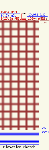
Site Elevation: 1025.3 meters (3364 ft) |
| Height of Structure: 60.7 meters (199 feet) |
| Overall Height Above Ground: 60.7 meters (199 feet) |
| Overall Height Above Mean Sea Level: 1086 meters (3563 feet) |
| K209BT C/R Height Above Mean Sea Level: 1060 meters (3478 ft)
|
| Owner Info | Global Tower, LLC. through American Towers, LLC
10 Presidential Way
Woburn, MA 01801
(678) 564-3236
faa-fcc@americantower.com |
| Contact Info | American Towers, LLC.
10 Presidential Way
Woburn, MA 01801
(678) 564-3236
faa-fcc@americantower.com |
