|
|
Antenna Structure Registration 1053046 |
 |
Registration Info | Registration Number: 1053046 |
| File Number: A0654139 |
| FAA Study: 96-ACE-0340-OE |
| FAA Issue Date: 05/24/1996 |
| Status: Constructed |
| Date Constructed: 11/20/1979 |
| FAA EMI: N |
| NEPA: N |
Structure Info
| Structure Type: TOWER |
| Structure Coordinates: 39-4-12.0 N 97-51-15.0 W (NAD 83) |
| Structure Coordinates: 39-04-12.0 N 97-51-13.9 W (Converted to NAD 27) |
| Structure Address: Tescott Junction |
| Structure City: Salina, KS |
| Structure County: Ottawa County |
| Painting & Lighting Info |
FAA Circular #: 70/7460-1J |
FAA Chapters: 3, 4, 5, 13 |
| Elevation Info |
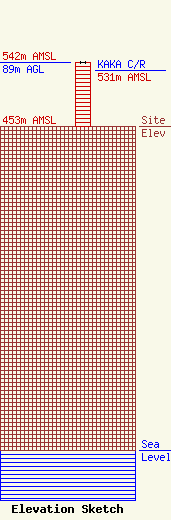
Site Elevation: 453 meters (1486 ft) |
| Height of Structure: 89 meters (292 feet) |
| Overall Height Above Ground: 89 meters (292 feet) |
| Overall Height Above Mean Sea Level: 542 meters (1778 feet) |
| KAKA C/R Height Above Mean Sea Level: 531 meters (1742 ft)
|
| Owner Info | AMERICAN FAMILY ASSOCIATION
P.O. DRAWER 2440
TUPELO, MS 38803
(662) 844-8888
JES@AFA.NET |
