|
|
Antenna Structure Registration 1053689 |
 |
Registration Info | Registration Number: 1053689 |
| File Number: A1010921 |
| FAA Study: 98-ASW-2105-OE |
| FAA Issue Date: 06/17/1998 |
| Status: Constructed |
| Date Constructed: 01/01/1998 |
| FAA EMI: N |
| NEPA: N |
Structure Info
| Structure Type: TOWER |
| Structure Coordinates: 29-25-6.0 N 98-29-32.0 W (NAD 83) |
| Structure Coordinates: 29-25-05.2 N 98-29-30.9 W (Converted to NAD 27) |
| Structure Address: 411 E Durango Blvd |
| Structure City: San Antonio, TX |
| Structure County: Bexar County |
| Painting & Lighting Info |
FCC Paragraph(s): 1, 3, 4, 13, 21 |
Remarks: RED LIGHTS/PAINT. |
| Elevation Info |
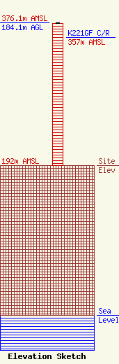
Site Elevation: 192 meters (630 ft) |
| Height of Structure: 183.1 meters (601 feet) |
| Overall Height Above Ground: 184.1 meters (604 feet) |
| Overall Height Above Mean Sea Level: 376.1 meters (1234 feet) |
| K221GF C/R Height Above Mean Sea Level: 357 meters (1171 ft)
|
| Owner Info | Crown Castle Towers 06-2 LLC
2000 Corporate Drive
Canonsburg, PA 15317
(724) 416-2000
Regulatory.Department@Crowncastle.com |
| Contact Info | Crown Castle
2000 Corporate Drive
Canonsburg, PA 15317
Don Snyder
(724) 416-2470
Don.Snyder@crowncastle.com |
