|
|
Antenna Structure Registration 1055024 |
 |
Registration Info | Registration Number: 1055024 |
| File Number: A1239639 |
| FAA Study: 98-AEA-1848-OE |
| FAA Issue Date: 07/29/1998 |
| Status: Constructed |
| Date Constructed: 01/01/1968 |
| FAA EMI: N |
| NEPA: N |
Structure Info
| Structure Type: TOWER |
| Structure Coordinates: 43-10-37.0 N 77-28-38.0 W (NAD 83) |
| Structure Coordinates: 43-10-36.8 N 77-28-39.0 W (Converted to NAD 27) |
| Structure Address: 1427 Five Mile Line Rd |
| Structure City: Penfield, NY |
| Structure County: Monroe County |
| Painting & Lighting Info |
FCC Paragraph(s): 1, 3, 4, 13, 21 |
Remarks: FAA APPROVED CHAPTERS 3,4,5,13 BUT ALSO APPROVED GRANDFATHERED LIGHTING (1, 3, 4, 13, 21). |
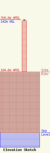
| Elevation Info |
Site Elevation: 164.6 meters (540 ft) |
| Height of Structure: 139 meters (456 feet) |
| Overall Height Above Ground: 142 meters (466 feet) |
| Overall Height Above Mean Sea Level: 306.6 meters (1006 feet) |
| Owner Info | K2 Towers III, LLC
57 E Washington St
Chagrin Falls, OH 44022
(440) 528-0333
rlepene@k2towers.com |
| Contact Info | K2 Towers III, LLC
57 E Washington St
Chagrin Falls, OH 44022
Greg Thompson
(440) 528-0333
gthompson@k2towers.com |
