|
|
Antenna Structure Registration 1056731 |
 |
Registration Info | Registration Number: 1056731 |
| File Number: A0935837 |
| FAA Study: 98-AEA-2075-OE |
| Status: Constructed |
| Date Constructed: 05/01/1982 |
| FAA EMI: N |
| NEPA: N |
Structure Info
| Structure Type: TOWER |
| Structure Coordinates: 40-51-8.0 N 72-45-53.0 W (NAD 83) |
| Structure Coordinates: 40-51-07.6 N 72-45-54.6 W (Converted to NAD 27) |
| Structure Address: 2 Miles Southeast Of |
| Structure City: Manorville, NY |
| Structure County: Suffolk County |
| Painting & Lighting Info |
FAA Circular #: 70/7460-1J |
FAA Chapters: 4, 8, 13 |
| Elevation Info |
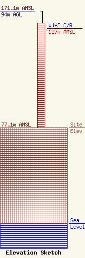
Site Elevation: 77.1 meters (253 ft) |
| Height of Structure: 84.4 meters (277 feet) |
| Overall Height Above Ground: 94 meters (308 feet) |
| Overall Height Above Mean Sea Level: 171.1 meters (561 feet) |
| WJVC C/R Height Above Mean Sea Level: 157 meters (515 ft)
|
| Owner Info | SBA Towers V, LLC
8051 Congress Avenue
Boca Raton, FL 33487
(561) 995-7670
ERoach@sbasite.com |
| Contact Info | SBA Towers V, LLC
8051 Congress Avenue
Boca Raton, FL 33487
(561) 995-7670
ERoach@sbasite.com |
