|
|
Antenna Structure Registration 1056734 |
 |
Registration Info | Registration Number: 1056734 |
| File Number: A1184129 |
| FAA Study: 2020-AEA-12512-OE |
| FAA Issue Date: 01/05/2021 |
| Status: Constructed |
| Date Constructed: 08/21/1998 |
| NEPA: N |
Structure Info
| Structure Type: LTOWER |
| Structure Coordinates: 40-48-8.4 N 73-17-10.3 W (NAD 83) |
| Structure Coordinates: 40-48-08.0 N 73-17-11.9 W (Converted to NAD 27) |
| Structure Address: Intersection Of Long Island Expressway & Sagtikos Parkway |
| Structure City: Islip, NY |
| Structure County: Suffolk County |
| Painting & Lighting Info |
FAA Circular #: 70/7460-1M |
FAA Chapters: 4, 8, 15 |
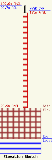
| Elevation Info |
Site Elevation: 29.9 meters (98 ft) |
| Height of Structure: 92.6 meters (304 feet) |
| Overall Height Above Ground: 99.7 meters (327 feet) |
| Overall Height Above Mean Sea Level: 129.6 meters (425 feet) |
| WWSK C/R Height Above Mean Sea Level: 125 meters (410 ft)
|
| Owner Info | CTI Towers Assets II, LLC
5000 Centre Green way
Cary, NC 27513
(919) 893-2841
mbertolino@ctitowers.com |
| Contact Info | CTI Towers Assets II, LLC
5000 Centre Green way
Cary, NC 27513
Matt Bertolino
(919) 893-2841
mbertolino@ctitowers.com |
