|
|
Antenna Structure Registration 1059624 |
 |
Registration Info | Registration Number: 1059624 |
| File Number: A1285995 |
| FAA Study: 2023-AEA-6665-OE |
| FAA Issue Date: 08/24/2023 |
| Status: Constructed |
| Date Constructed: 01/01/1983 |
| NEPA: N |
Structure Info
| Structure Type: LTOWER |
| Structure Coordinates: 40-10-15.3 N 74-1-40.3 W (NAD 83) |
| Structure Coordinates: 40-10-14.9 N 74-01-41.8 W (Converted to NAD 27) |
| Structure Address: 1731 Main St (203690) |
| Structure City: Lake Como, NJ |
| Structure County: Monmouth County |
| Painting & Lighting Info |
FAA Circular #: 70/7460-1L |
FAA Chapters: 4, 8, 12 |
Remarks: OM&L to remain the same as prior study = A MED-DUAL SYSTEM |
Remarks: PRIOR STUDY 2022-AEA-8936-OE |
Remarks: OM&L to remain the same as prior study = A MED-DUAL SYSTEM |
Remarks: PRIOR STUDY 2022-AEA-8936-OE |
| Elevation Info |
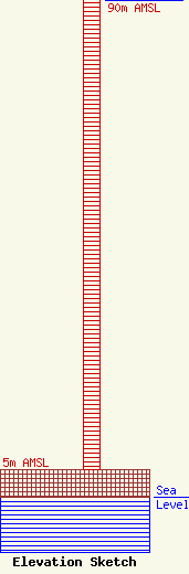
Site Elevation: 5 meters (16 ft) |
| Height of Structure: 87.8 meters (288 feet) |
| Overall Height Above Ground: 89 meters (292 feet) |
| Overall Height Above Mean Sea Level: 94 meters (308 feet) |
| WRAT C/R Height Above Mean Sea Level: 90 meters (295 ft)
|
| Owner Info | American Towers LLC
10 Presidential Way
Woburn, MA 01801
(781) 926-4500
faa-fcc@americantower.com |
| Contact Info | American Towers LLC
10 Presidential Way
Woburn, MA 01801
(781) 926-4500
faa-fcc@americantower.com |
