|
|
Antenna Structure Registration 1061876 |
 |
Registration Info | Registration Number: 1061876 |
| File Number: A1192164 |
| FAA Study: 98-AEA-3697-OE |
| FAA Issue Date: 03/01/1999 |
| Status: Constructed |
| Date Constructed: 12/01/1982 |
| FAA EMI: N |
| NEPA: N |
Structure Info
| Structure Type: TOWER |
| Structure Coordinates: 41-27-25.0 N 74-26-23.0 W (NAD 83) |
| Structure Coordinates: 41-27-24.7 N 74-26-24.4 W (Converted to NAD 27) |
| Structure Address: 229 Monhagen Avenue |
| Structure City: Middletown, NY |
| Structure County: Orange County |
| Painting & Lighting Info |
FAA Circular #: 70/7460-1J |
FAA Chapters: 3, 4, 5, 13 |
Remarks: PREV. 90-AEA-0166-OE. |
| Elevation Info |
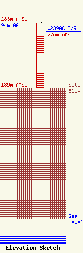
Site Elevation: 189 meters (620 ft) |
| Height of Structure: 93 meters (305 feet) |
| Overall Height Above Ground: 94 meters (308 feet) |
| Overall Height Above Mean Sea Level: 283 meters (928 feet) |
| W239AC C/R Height Above Mean Sea Level: 270 meters (886 ft)
|
| Owner Info | Townsquare Media Poughkeepsie, LLC
1 Manhattanville Road
Purchase, NY 10577
(203) 861-0900
fcccontact@townsquaremedia.com |
| Contact Info | Townsquare Media Poughkeepsie, LLC
1 Manhattanville Road
Purchase, NY 10577
(203) 861-0900
fcccontact@townsquaremedia.com |
