|
|
Antenna Structure Registration 1064715 |
 |
Registration Info | Registration Number: 1064715 |
| File Number: A1203964 |
| FAA Study: 2021-ACE-657-OE |
| FAA Issue Date: 02/16/2021 |
| Status: Constructed |
| Date Constructed: 02/14/2003 |
| NEPA: N |
Structure Info
| Structure Type: GTOWER |
| Structure Coordinates: 39-1-19.9 N 94-30-49.7 W (NAD 83) |
| Structure Coordinates: 39-01-19.9 N 94-30-48.9 W (Converted to NAD 27) |
| Structure Address: 6309 E. 56th St. (atc Site # 282654) |
| Structure City: Kansas City, MO |
| Structure County: Jackson County |
| Painting & Lighting Info |
FAA Circular #: 70/7460-1M |
FAA Chapters: 4, 9, 15 |
| Elevation Info |
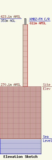
Site Elevation: 270.1 meters (886 ft) |
| Height of Structure: 323.5 meters (1061 feet) |
| Overall Height Above Ground: 353 meters (1158 feet) |
| Overall Height Above Mean Sea Level: 623.1 meters (2044 feet) |
| KMBZ-FM C/R Height Above Mean Sea Level: 611 meters (2005 ft)
|
| Owner Info | American Towers LLC
10 Presidential Way
Woburn, MA 01801
(781) 926-4500
faa-fcc@americantower.com |
| Contact Info | American Towers LLC
10 Presidential Way
Woburn, MA 01801
(781) 926-4500
faa-fcc@americantower.com |
