|
|
Antenna Structure Registration 1064894 |
 |
Registration Info | Registration Number: 1064894 |
| File Number: A0556348 |
| FAA Study: 99-AEA-0741-OE |
| FAA Issue Date: 04/29/1999 |
| Status: Constructed |
| Date Constructed: 01/01/1980 |
| FAA EMI: N |
| NEPA: N |
Structure Info
| Structure Type: TOWER |
| Structure Coordinates: 40-38-45.0 N 73-34-35.0 W (NAD 83) |
| Structure Coordinates: 40-38-44.6 N 73-34-36.5 W (Converted to NAD 27) |
| Structure Address: 408 Main St |
| Structure City: Freeport, NY |
| Structure County: Nassau County |
| Painting & Lighting Info |
FAA Circular #: 70/7460-1J |
FAA Chapters: 3, 4, 5, 13 |
| Elevation Info |
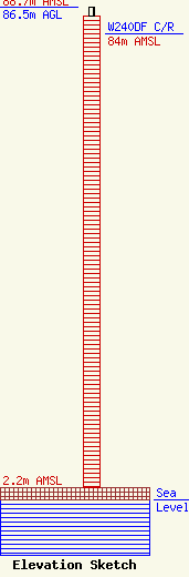
Site Elevation: 2.2 meters (7 ft) |
| Height of Structure: 85 meters (279 feet) |
| Overall Height Above Ground: 86.5 meters (284 feet) |
| Overall Height Above Mean Sea Level: 88.7 meters (291 feet) |
| W240DF C/R Height Above Mean Sea Level: 84 meters (276 ft)
|
| Owner Info | WGBB-AM, INC.
133-11 41 ROAD SUITE 1A
FLUSHING, NY 11355
(718) 661-3933
|
| Contact Info | LEVENTHAL SENTER & LERMAN PLLC
2000 K STREET, NW SUITE 600
WASHINGTON, DC 20006
HOWARD TOPEL, ESQ.
(202) 429-8970
HTOPEL@LSL-LAW.COM |
