|
|
Antenna Structure Registration 1200135 |
 |
Registration Info | Registration Number: 1200135 |
| File Number: A1264737 |
| FAA Study: 2022-ASW-14454-OE |
| FAA Issue Date: 01/25/2023 |
| Status: Constructed |
| Date Constructed: 09/29/2006 |
| NEPA: N |
Structure Info
| Structure Type: LTOWER |
| Structure Coordinates: 34-11-13.0 N 101-45-9.9 W (NAD 83) |
| Structure Coordinates: 34-11-12.7 N 101-45-08.3 W (Converted to NAD 27) |
| Structure Address: 4101 Olton Road (076529) |
| Structure City: Plainview, TX |
| Structure County: Hale County |
| Painting & Lighting Info |
FAA Chapters: NONE |
Remarks: PRIOR STUDY 2016-ASW-12291-OE |
| Elevation Info |
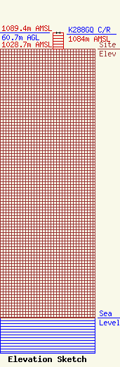
Site Elevation: 1028.7 meters (3375 ft) |
| Height of Structure: 60 meters (197 feet) |
| Overall Height Above Ground: 60.7 meters (199 feet) |
| Overall Height Above Mean Sea Level: 1089.4 meters (3574 feet) |
| K288GQ C/R Height Above Mean Sea Level: 1084 meters (3556 ft)
|
| Owner Info | American Towers LLC
10 Presidential Way
Woburn, MA 01801
(781) 926-4500
faa-fcc@americantower.com |
| Contact Info | American Towers LLC
10 Presidential Way
Woburn, MA 01801
(781) 926-4500
faa-fcc@americantower.com |
