|
|
Antenna Structure Registration 1204508 |
 |
Registration Info | Registration Number: 1204508 |
| File Number: A1011492 |
| FAA Study: 2013-ANE-580-OE |
| FAA Issue Date: 06/26/2013 |
| Status: Constructed |
| Date Constructed: 06/15/2001 |
| NEPA: N |
Structure Info
| Structure Type: LTOWER |
| Structure Coordinates: 41-23-45.3 N 73-25-26.2 W (NAD 83) |
| Structure Coordinates: 41-23-45.0 N 73-25-27.8 W (Converted to NAD 27) |
| Structure Address: 7 West View Drive |
| Structure City: Danbury, CT |
| Structure County: Fairfield County |
| Painting & Lighting Info |
FAA Chapters: NONE |
Remarks: PRIOR STUDY 1997-ANE-617-OE |
| Elevation Info |
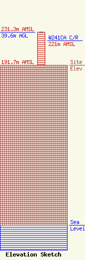
Site Elevation: 191.7 meters (629 ft) |
| Height of Structure: 39.6 meters (130 feet) |
| Overall Height Above Ground: 39.6 meters (130 feet) |
| Overall Height Above Mean Sea Level: 231.3 meters (759 feet) |
| W241CA C/R Height Above Mean Sea Level: 221 meters (725 ft)
|
| Info |
| Info |
