|
|
Antenna Structure Registration 1214030 |
 |
Registration Info | Registration Number: 1214030 |
| File Number: A0599073 |
| FAA Study: 98-AEA-0357-OE |
| FAA Issue Date: 03/13/1998 |
| Status: Granted |
| Date Constructed: 06/23/2000 |
| NEPA: N |
Structure Info
| Structure Type: TOWER |
| Structure Coordinates: 40-59-47.0 N 74-16-48.0 W (NAD 83) |
| Structure Coordinates: 40-59-46.6 N 74-16-49.5 W (Converted to NAD 27) |
| Structure Address: Tower Road |
| Structure City: Pompton Lakes, NJ |
| Structure County: Passaic County |
| Painting & Lighting Info |
FAA Circular #: 70/7460-1J |
FAA Chapters: 4, 8, 13 |
| Elevation Info |
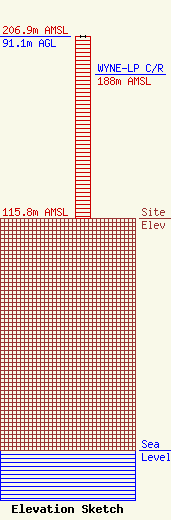
Site Elevation: 115.8 meters (380 ft) |
| Height of Structure: 91.1 meters (299 feet) |
| Overall Height Above Ground: 91.1 meters (299 feet) |
| Overall Height Above Mean Sea Level: 206.9 meters (679 feet) |
| WYNE-LP C/R Height Above Mean Sea Level: 188 meters (617 ft)
|
| Owner Info | NORTH JERSEY POLICE RADIO ASSOCIATION INCORPORATED
10 High Street
Butler, NJ 07405
(973) 714-1567
card@butlerpd.com |
