|
|
Antenna Structure Registration 1214327 |
 |
Registration Info | Registration Number: 1214327 |
| File Number: A1051598 |
| FAA Study: 2016-ASW-2905-OE |
| FAA Issue Date: 03/16/2016 |
| Status: Constructed |
| Date Constructed: 07/12/2001 |
| NEPA: N |
Structure Info
| Structure Type: GTOWER |
| Structure Coordinates: 29-26-29.9 N 98-30-22.8 W (NAD 83) |
| Structure Coordinates: 29-26-29.1 N 98-30-21.7 W (Converted to NAD 27) |
| Structure Address: 1010 W. Laurel St. (atc Site # 282679) |
| Structure City: San Antonio, TX |
| Structure County: Bexar County |
| Painting & Lighting Info |
FAA Circular #: 70/7460-1L |
FAA Chapters: 4, 8, 12 |
Remarks: PRIOR STUDY 2000-ASW-1251-OE |
| Elevation Info |
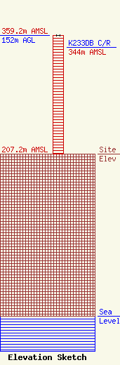
Site Elevation: 207.2 meters (680 ft) |
| Height of Structure: 152 meters (499 feet) |
| Overall Height Above Ground: 152 meters (499 feet) |
| Overall Height Above Mean Sea Level: 359.2 meters (1178 feet) |
| K233DB C/R Height Above Mean Sea Level: 344 meters (1129 ft)
|
| Owner Info | American Towers LLC
10 Presidential Way
Woburn, MA 01801
(678) 564-3236
faa-fcc@americantower.com |
| Contact Info | American Towers, LLC.
10 Presidential Way
Woburn, MA 01801
(678) 564-3236
faa-fcc@americantower.com |
