|
|
Antenna Structure Registration 1229046 |
 |
Registration Info | Registration Number: 1229046 |
| File Number: A0898196 |
| FAA Study: 86-AWP-0064-OE |
| FAA Issue Date: 01/01/1986 |
| Status: Constructed |
| Date Constructed: 01/01/2003 |
| FAA EMI: N |
| NEPA: N |
Structure Info
| Structure Type: 2TOWER |
| Structure Coordinates: 34-13-57.0 N 118-4-27.2 W (NAD 83) |
| Structure Coordinates: 34-13-57.0 N 118-04-24.0 W (Converted to NAD 27) |
| Structure Address: 123 Cbs Lane |
| Structure City: Mt. Wilson, CA |
| Structure County: Los Angeles County |
| Painting & Lighting Info |
FAA Chapters: NONE |
Remarks: 2TOWER NOS RECORD 05-0230. |
Remarks: ADDED PER DOF 05-0230. |
Remarks: 2TOWER NOS RECORD 05-0230. |
| Elevation Info |
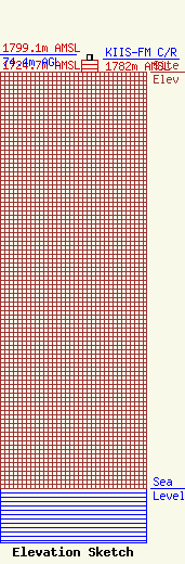
Site Elevation: 1724.7 meters (5658 ft) |
| Height of Structure: 48.8 meters (160 feet) |
| Overall Height Above Ground: 74.4 meters (244 feet) |
| Overall Height Above Mean Sea Level: 1799.1 meters (5903 feet) |
| KIIS-FM C/R Height Above Mean Sea Level: 1782 meters (5846 ft)
|
| Owner Info | American Towers LLC
10 Presidential Way
Woburn, MA 01801
(678) 564-3236
FAA-FCC@americantower.com |
| Contact Info | American Tower, LLC
10 Presidential Way
Woburn, MA 01801
(678) 564-3236
FAA-FCC@americantower.com |
