|
|
Antenna Structure Registration 1232992 |
 |
Registration Info | Registration Number: 1232992 |
| File Number: A1239010 |
| FAA Study: 02-AGL-1161-OE |
| FAA Issue Date: 03/06/2002 |
| Status: Constructed |
| Date Constructed: 09/23/2009 |
| FAA EMI: N |
| NEPA: N |
Structure Info
| Structure Type: BMAST |
| Structure Coordinates: 41-53-6.1 N 87-37-17.7 W (NAD 83) |
| Structure Coordinates: 41-53-06.0 N 87-37-17.5 W (Converted to NAD 27) |
| Structure Address: Amoco Building |
| Structure City: Chicago, IL |
| Structure County: Cook County |
| Painting & Lighting Info |
FCC Paragraph(s): 1, 3, 8, 17, 21 |
Remarks: OM&L TO REMAIN PAINT RED LIGHTS AS PER PRIOR STUDY 01-AGL-8745-OE |
| Elevation Info |
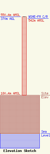
Site Elevation: 180.4 meters (592 ft) |
| Height of Structure: 370 meters (1214 feet) |
| Overall Height Above Ground: 370 meters (1214 feet) |
| Overall Height Above Mean Sea Level: 550.4 meters (1806 feet) |
| WSHE-FM C/R Height Above Mean Sea Level: 542 meters (1778 ft)
|
| Owner Info | Hubbard Radio Chicago, LLC
3415 University Avenue, West
St. Paul, MN 55114-2009
(651) 642-4336
kshuldes@hbi.com |
| Contact Info | Wilkinson Barker Knauer, LLP
1800 M Street, N.W.
Washington, DC 20036
David O'Connor
(202) 383-3429
doconnor@wbklaw.com |
