|
|
Antenna Structure Registration 1235630 |
 |
Registration Info | Registration Number: 1235630 |
| File Number: A1047299 |
| FAA Study: 02-ASO-0908-OE |
| Status: Constructed |
| Date Constructed: 09/01/2003 |
| FAA EMI: N |
| NEPA: N |
Structure Info
|
| Structure Coordinates: 31-50-9.6 N 88-52-21.2 W (NAD 83) |
| Structure Coordinates: 31-50-09.0 N 88-52-21.0 W (Converted to NAD 27) |
| Structure Address: 1/2 Mile N. Of Clarke/wayne County Line. 1.8 Miles East Of Highway 21. |
| Structure City: Heidelberg, MS |
| Structure County: Clarke County |
| Painting & Lighting Info |
FAA Circular #: 70/7460-1K |
FAA Chapters: 4, 8, 12 |
| Elevation Info |
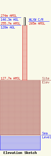
Site Elevation: 127.7 meters (419 ft) |
| Height of Structure: 128 meters (420 feet) |
| Overall Height Above Ground: 146.3 meters (480 feet) |
| Overall Height Above Mean Sea Level: 274 meters (899 feet) |
| WLXW C/R Height Above Mean Sea Level: 265 meters (869 ft)
|
| Owner Info | Educational Media Foundation
5700 West Oaks Blvd.
Rocklin, CA 95765
(916) 251-1600
efile@emfbroadcasting.com |
| Contact Info | Educational Media Foundation
5700 West Oaks Blvd.
Rocklin, CA 95765
Joe Miller
(916) 251-1600
efile@emfbroadcasting.com |
