|
|
Antenna Structure Registration 1237630 |
 |
Registration Info | Registration Number: 1237630 |
| File Number: A0654174 |
| FAA Study: 2002-ASW-5394-OE |
| FAA Issue Date: 01/28/2003 |
| Status: Constructed |
| Date Constructed: 03/25/2004 |
| FAA EMI: N |
| NEPA: N |
Structure Info
| Structure Type: TOWER |
| Structure Coordinates: 34-3-58.2 N 101-42-17.6 W (NAD 83) |
| Structure Coordinates: 34-03-57.9 N 101-42-16.0 W (Converted to NAD 27) |
| Structure Address: From Intersection Of Us 70 And Fm400, 8m S On Fm400, From 1914 Right 1/2 To Site |
| Structure City: Plainview, TX |
| Structure County: Hale County |
| Painting & Lighting Info |
FAA Circular #: 70/7460-1K |
FAA Chapters: 4, 8, 12 |
Remarks: PRIOR STUDY 2003-ASW-374-OE |
| Elevation Info |
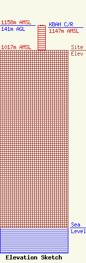
Site Elevation: 1017 meters (3337 ft) |
| Height of Structure: 141 meters (463 feet) |
| Overall Height Above Ground: 141 meters (463 feet) |
| Overall Height Above Mean Sea Level: 1158 meters (3799 feet) |
| KBAH C/R Height Above Mean Sea Level: 1147 meters (3763 ft)
|
| Owner Info | AMERICAN FAMILY ASSOCIATION
P.O. DRAWER 2440
TUPELO, MS 38803
(662) 844-8888
JES@AFA.NET |
| Info |
