|
|
Antenna Structure Registration 1261660 |
 |
Registration Info | Registration Number: 1261660 |
| File Number: A0906608 |
| FAA Study: 86-AEA-0707-OE |
| FAA Issue Date: 12/29/1986 |
| Status: Granted |
| Date Constructed: 02/06/2008 |
| FAA EMI: N |
| NEPA: N |
Structure Info
| Structure Type: BTWR |
| Structure Coordinates: 40-51-15.0 N 73-58-58.0 W (NAD 83) |
| Structure Coordinates: 40-51-14.6 N 73-58-59.5 W (Converted to NAD 27) |
| Structure Address: 555 North Avenue |
| Structure City: Fort Lee, NJ |
| Structure County: Bergen County |
| Painting & Lighting Info |
FAA Chapters: NONE |
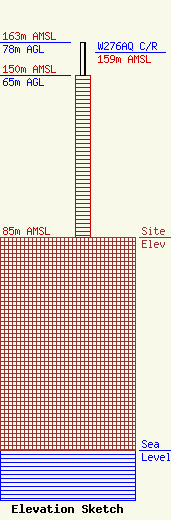
| Elevation Info |
Site Elevation: 85 meters (279 ft) |
| Height of Structure: 65 meters (213 feet) |
| Overall Height Above Ground: 78 meters (256 feet) |
| Overall Height Above Mean Sea Level: 163 meters (535 feet) |
| W276AQ C/R Height Above Mean Sea Level: 159 meters (522 ft)
|
| Owner Info | Bridgelight, LLC
127 White Oak Lane
Old Bridge, NJ 08857
(732) 901-5525
rob@thebridgefm.org |
| Contact Info | Fletcher Head and Hildreth, PLC
11th FL, 1300 North 17th St
Arlington, VA 22209
Harry Martin
(703) 812-0415
martin@fhhlaw.com |
