|
|
Antenna Structure Registration 1282424 |
 |
Registration Info | Registration Number: 1282424 |
| File Number: A0829972 |
| FAA Study: 2011-AWP-491-OE |
| FAA Issue Date: 02/28/2011 |
| Status: Constructed |
| Date Constructed: 03/13/2013 |
| FAA EMI: N |
| NEPA: N |
Structure Info
| Structure Type: TOWER |
| Structure Coordinates: 39-12-58.7 N 119-47-29.9 W (NAD 83) |
| Structure Coordinates: 39-12-59.0 N 119-47-26.2 W (Converted to NAD 27) |
| Structure Address: 1032 Duck Hill Road |
| Structure City: Carson City, NV |
| Structure County: Washoe County |
| Painting & Lighting Info |
FAA Chapters: NONE |
Remarks: Removed expiration date from determination. Scenario 1./jjs/case#635066 |
| Elevation Info |
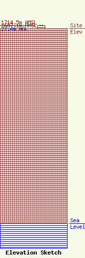
Site Elevation: 1687.1 meters (5535 ft) |
| Height of Structure: 24.4 meters (80 feet) |
| Overall Height Above Ground: 27.4 meters (90 feet) |
| Overall Height Above Mean Sea Level: 1714.5 meters (5625 feet) |
| KNVC-LP C/R Height Above Mean Sea Level: 1698 meters (5571 ft)
|
| Owner Info | Amatuer Radio Station K7UI
1032 Duck Hill Road
Carson City, NV 89704
David Metts
(775) 841-5784
dmetts@hdiss.net |
