|
WZLC Channel: 205C1 88.9 MHz
Summerville, South Carolina
Service: FM - A full-service FM station or application.
Facility ID: 173901
FRN: 0001843341
Fac. Service: FM
Status: LIC
Application Accepted: 01/06/2014
Application Granted: 01/17/2014
File Number: BLED-20140106DWC
License Expires: 12/01/2027
Prefix Type: This is a license for a noncommercial educational FM station
Application Type: License To Cover
FCC Website Links:
LMS Facility Details
This Application
Other WZLC Applications
Including Superseded Applications
Service Contour - Open Street Map or USGS Map (60 dBu)
Service Contour - KML / Google Earth (60 dBu)
Public Inspection Files
Facility Type: NON-COMMERCIAL EDUC. FM
Class: C1, A Zone II station; with 50kW-100kW ERP and a class contour distance 52km-72km
Site Location: 33-11-33.6 N 80-33-50.4 W (NAD 83)
Site Location: 33-11-33.0 N 80-33-51.0 W (Converted to NAD 27)
Effective Radiated Power: 70 kW Horiz. ; 54.2 kW Vert.
Transmitter Output Power: 9 kW
Antenna Center HAAT: 96 m (315 ft.)
Antenna Center AMSL: 124 m (407 ft.)
Antenna Center HAG: 97 m (318 ft.)
Site Elevation: 27 m. (89 ft.)
Height Overall*: 106.4 m (349 ft.)
(* As Filed In This Application, may differ from ASR Data, Below.)
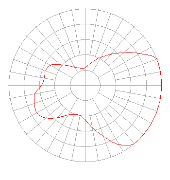
Directional Antenna
Antenna Make/Model: Shivley 6025-4/1, four sections
Antenna ID: 112867
Polarization:
|
Structure Information
Structure Registration Number 1286533
Structure Type: LTOWER
Registered To:
SWI Funds Tower Holdings, LLC
Structure Address:
Hwy 15 N
St. George, SC
County Name: Dorchester County
ASR Issued: 05/03/2021
Date Built: 01/04/2014
Site Elevation: 27.1 m (89 ft.)
Structure Height: 105.5 m (346 ft.)
Height Overall: 106.4 m (349 ft.)
Overall Height AMSL: 133.5 m (438 ft.)
FAA Determination: 09/26/2012
FAA Study #: 2012-ASO-8374-OE
FAA Circular #: 70/7460-1K
Paint & Light FAA Chapters: 4, 8, 12
Removed expiration and final dates from determination. Scenario 2./jjs/case#635066
33-11-33.6 N 80-33-50.4 W (NAD 83)
33-11-33.0 N 80-33-51.0 W
(Converted to NAD 27)
|
WZLC(FM) Licensee Information
Radio Training Network, Inc
5015 South Florida Ave
Suite 409
Lakeland, FL 33813-2562
Phone: 863-644-3464
Not-for-Profit | 20140106DWC Applicant Information
Robert M. Cauthen
Date: 01/06/2014
Application Certifier
Spirit Broadcasting Group, Inc.
P.O. Box 15
Chester, SC 29706
Applicant
Timothy L. Warner, P.E.
Timothy L. Warner, Inc.
Post Office Box 8045
Asheville, NC 28814-8045
Technical Consultant
David Tillotson
Law Office of David Tillotson
|