
FCCInfo.com
A Service of Cavell, Mertz & Associates, Inc.
(855) FCC-INFO
|
|
WVZA from 07/22/2009 WVZA from 10/04/1991 |
|  |
|
|||||||||||||||
|
|
WVZA Channel: 224B1 92.7 MHz Herrin, Illinois Service: FM - A full-service FM station or application. Facility ID: 124 Fac. Service: FM Status: LIC 73.215 Station Application Accepted: 10/02/1996 Application Granted: 03/31/1997 File Number: BLH-19961002KB Prefix Type: This is a license for a commercial FM station Application Type: License To Cover FCC Website Links: LMS Facility Details This Application CDBS Application Other WVZA Applications Other WVZA Applications in CDBS Including Superseded Applications Mailing Address Correspondence for WVZA Correspondence related to application BLH-19961002KB Service Contour - Open Street Map or USGS Map (57 dBu) Service Contour - KML / Google Earth (57 dBu) Public Inspection Files Facility Type: FM STATION Class: B1, A Zone I or I-A station; with 6kW-25kW ERP and a class contour distance 28km-39km Site Location: 37-46-28.2 N 89-05-50.3 W (NAD 83) Site Location: 37-46-28.0 N 89-05-50.0 W (Converted to NAD 27) Effective Radiated Power: 25 kW Antenna Center HAAT: 100 m (328 ft.) Antenna Center AMSL: 224 m (735 ft.) Antenna Center HAG: 79 m (259 ft.) Calculated Site Elevation: 145 m. (476 ft.) Height Overall*: 91 m (299 ft.) (* As Filed In This Application, may differ from ASR Data, Below.) Directional Antenna Antenna Make/Model: Oddball; usually designed by Applicant ODD960221IG Antenna ID: 14921 Polarization: | ||||||||||||||||||
| Antenna Data for Antenna Id: 14921 WVZA FM File: BLH-19961002KB Oddball; usually designed by Applicant - ODD960221IG Service: FM | 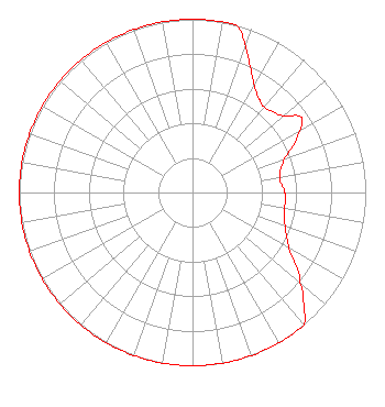 | ||||||||||||||||||
| Azimuth | Ratio | Azimuth | Ratio | Azimuth | Ratio | Azimuth | Ratio | ||||||||||||
| 0 | 1.000 | 10 | 1.000 | 15 | 0.996 | 20 | 0.897 | ||||||||||||
| 25 | 0.792 | 30 | 0.713 | 35 | 0.666 | 40 | 0.645 | ||||||||||||
| 50 | 0.684 | 55 | 0.762 | 60 | 0.713 | 70 | 0.566 | ||||||||||||
| 80 | 0.510 | 90 | 0.533 | 95 | 0.540 | 100 | 0.537 | ||||||||||||
| 110 | 0.569 | 120 | 0.645 | 130 | 0.812 | 135 | 0.907 | ||||||||||||
| 140 | 1.000 | 150 | 1.000 | 160 | 1.000 | 170 | 1.000 | ||||||||||||
| 180 | 1.000 | 190 | 1.000 | 200 | 1.000 | 210 | 1.000 | ||||||||||||
| 220 | 1.000 | 230 | 1.000 | 240 | 1.000 | 250 | 1.000 | ||||||||||||
| 260 | 1.000 | 270 | 1.000 | 280 | 1.000 | 290 | 1.000 | ||||||||||||
| 300 | 1.000 | 310 | 1.000 | 320 | 1.000 | 330 | 1.000 | ||||||||||||
| 340 | 1.000 | 350 | 1.000 | ||||||||||||||||
Structure Registration Number 1009770 [ASR Heights Differ from WVZA Application] Structure Type: TOWER Registered To: American Towers LLC Structure Address: Sycamore & Greenbriar Rd. (cartersville# 50718) Carterville, IL County Name: Williamson County ASR Issued: 01/15/2013 Date Built: 08/27/2006 Site Elevation: 145.7 m (478 ft.) Structure Height: 90.2 m (296 ft.) Height Overall: 91.4 m (300 ft.) Overall Height AMSL: 237.1 m (778 ft.) FAA Determination: 02/20/2006 FAA Study #: 2006-AGL-858-OE FAA Circular #: 70/7460-1K Paint & Light FAA Chapters: 4, 8, 12 PRIOR STUDY 2002-AGL-6813-OE 37-46-27.6 N 89-05-49.8 W (NAD 83) 37-46-27.4 N 89-05-49.5 W (Converted to NAD 27) |
Post Office Box 1508 Mount Vernon, IL 62864 Phone: 618-242-3500 Limited Liability Company | Date: 10/02/1996 Application Certifier CUMULUS LICENSING CORP. 3-d Communicatons Corporation 330 East Kilbourn Ave. Suite 250 Milwaukee, WI 53202 Applicant | |||||||||||||||||
| |||||||||||||||||||