|
KBDE(FM)
Call Sign History
KBDE from 03/20/1998
|
89.9 MHz | 
|
Temple, TX
|
|
KBDE Channel: 210C2 89.9 MHz
Temple, Texas
Service: FM - A full-service FM station or application.
Facility ID: 85761
FRN: 0005025911
Fac. Service: FM
Status: LIC
Application Accepted: 11/23/1999
Application Granted: 07/09/2001
File Number: BLED-19991008ABH
License Expires: 08/01/2029
Prefix Type: This is a license for a noncommercial educational FM station
Application Type: License To Cover
FCC Website Links:
LMS Facility Details
This Application
Other KBDE Applications
Including Superseded Applications
Service Contour - Open Street Map or USGS Map (60 dBu)
Service Contour - KML / Google Earth (60 dBu)
Public Inspection Files
Facility Type: NON-COMMERCIAL EDUC. FM
Class: C2, A Zone II station; with 25kW-50kW ERP and a class contour distance 39km-52km
Site Location: 31-16-05.6 N 97-21-35.0 W (NAD 83)
Site Location: 31-16-05.0 N 97-21-34.0 W (Converted to NAD 27)
Effective Radiated Power: 0 kW Horiz. ; 11.5 kW Vert.
Transmitter Output Power: 3.48 kW
Antenna Center HAAT: 0 m Horiz.; 149 m Vert.
Antenna Center AMSL: 0 m Horiz.; 361 m Vert.
Antenna Center HAG: 0 m Horiz.; 127 m Vert.
Site Elevation: 234 m. (768 ft.)
Height Overall*: 137 m (449 ft.)
(* As Filed In This Application, may differ from ASR Data, Below.)
Directional Antenna
Antenna Make/Model: Shivley 6513-4 SSDA
Antenna ID: 15558
Polarization:
|
Antenna Data for Antenna Id: 15558
KBDE FM File: BLED-19991008ABH
Shivley - 6513-4 SSDA
Service: FM
|
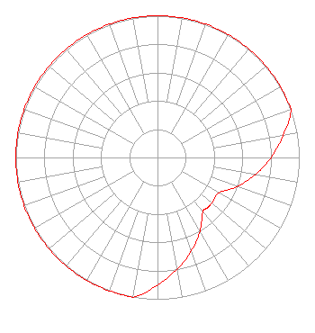 |
| Azimuth | Ratio | Azimuth | Ratio | Azimuth | Ratio | Azimuth | Ratio |
| 0 | 1.000 | 10 | 1.000 | 20 | 1.000 | 30 | 1.000 |
| 40 | 1.000 | 45 | 1.000 | 50 | 1.000 | 60 | 1.000 |
| 70 | 1.000 | 80 | 0.900 | 90 | 0.800 | 100 | 0.700 |
| 110 | 0.600 | 120 | 0.500 | 130 | 0.500 | 135 | 0.500 |
| 140 | 0.500 | 150 | 0.600 | 160 | 0.700 | 170 | 0.800 |
| 180 | 0.900 | 190 | 1.000 | 200 | 1.000 | 210 | 1.000 |
| 220 | 1.000 | 225 | 1.000 | 230 | 1.000 | 240 | 1.000 |
| 250 | 1.000 | 260 | 1.000 | 270 | 1.000 | 280 | 1.000 |
| 290 | 1.000 | 300 | 1.000 | 310 | 1.000 | 315 | 1.000 |
| 320 | 1.000 | 330 | 1.000 | 340 | 1.000 | 350 | 1.000 |
|
Structure Information
Structure Registration Number 1053086
Structure Type: TOWER
Registered To:
AMERICAN FAMILY ASSOCIATION
Structure Address:
1 Mile N. Of The Intersection Of Elm Creek And E. Payne Roads
Moody, TX
County Name: McLennan County
ASR Issued: 10/19/2009
Date Built: 07/15/1999
Site Elevation: 234 m (768 ft.)
Structure Height: 137 m (449 ft.)
Height Overall: 137 m (449 ft.)
Overall Height AMSL: 371 m (1217 ft.)
FAA Determination: 06/10/1998
FAA Study #: 98-ASW-1984-OE
FAA Circular #: 70/7460-1J
Paint & Light FAA Chapters: 4, 6, 13
31-16-06.0 N 97-21-35.0 W (NAD 83)
31-16-05.4 N 97-21-34.0 W
(Converted to NAD 27)
|
KBDE(FM) Licensee Information
American Family Association
PO Drawer 2440
Tupelo, MS 38803
Phone: 662-844-8888
Not-for-Profit | 19991008ABH Applicant Information
Donald E. Wilder
Date: 10/08/1999
Application Certifier
American Family Association
P.O. Drawer 2440
Tupelo, MS 38803
Applicant
Technical Consultant
|
Associated Land Mobile Licenses
|
| (No Records Found) |
| Associated Microwave Licenses
|
| (No Records Found) |
|
