FCCInfo.com
A Service of Cavell, Mertz & Associates, Inc.
(855) FCC-INFO
|
|
W270CT from 02/22/2016 W217CE from 01/29/2016 W214BS from 06/06/2007 W268AI from 04/07/2004 |
|
|
||||||||||||||||
|
|
W297BY Channel: 297D 107.3 MHz Franklin, Wisconsin Service: FX - A translator or application for a translator. Facility ID: 150179 FRN: 0003725439 Fac. Service: FX Programming Delivery Method: Unspecified Status: LIC Application Accepted: 06/09/2017 Application Granted: 06/20/2017 File Number: BLFT-20170609AAP License Expires: 12/01/2028 Prefix Type: This is a license for a translator Application Type: License To Cover FCC Website Links: LMS Facility Details This Application Other W297BY Applications Including Superseded Applications Service Contour - Open Street Map or USGS Map (60 dBu) Service Contour - KML / Google Earth (60 dBu) Class: D, A Noncommercial educational operating with no more than 10W Site Location: 42-51-20.1 N 87-50-41.3 W (NAD 83) Site Location: 42-51-20.0 N 87-50-41.0 W (Converted to NAD 27) Effective Radiated Power: 0.25 kW Transmitter Output Power: 0.374 kW Antenna Center AMSL: 303 m (994 ft.) Antenna Center HAG: 90 m (295 ft.) Site Elevation: 213 m. (699 ft.) Height Overall*: 152 m (499 ft.) (* As Filed In This Application, may differ from ASR Data, Below.) Directional Antenna Antenna Make/Model: None Antenna ID: 127400 Polarization:
| ||||||||||||||||||
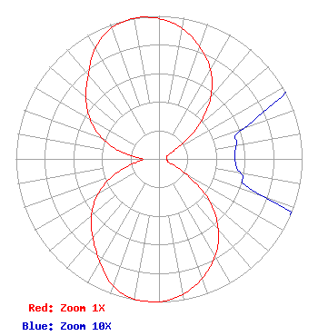
| Antenna Data for Antenna Id: 127400 W297BY FX File: BLFT-20170609AAP None - Service: FX |  | ||||||||||||||||||
| Azimuth | Ratio | Azimuth | Ratio | Azimuth | Ratio | Azimuth | Ratio | ||||||||||||
| 0 | 0.981 | 10 | 0.927 | 20 | 0.833 | 30 | 0.719 | ||||||||||||
| 40 | 0.562 | 50 | 0.354 | 60 | 0.131 | 70 | 0.063 | ||||||||||||
| 80 | 0.055 | 90 | 0.053 | 100 | 0.058 | 110 | 0.080 | ||||||||||||
| 120 | 0.228 | 130 | 0.463 | 140 | 0.645 | 150 | 0.785 | ||||||||||||
| 160 | 0.887 | 170 | 0.961 | 180 | 1.000 | 190 | 0.996 | ||||||||||||
| 200 | 0.945 | 210 | 0.827 | 220 | 0.720 | 230 | 0.617 | ||||||||||||
| 240 | 0.492 | 250 | 0.342 | 260 | 0.178 | 270 | 0.114 | ||||||||||||
| 280 | 0.262 | 290 | 0.423 | 300 | 0.557 | 310 | 0.667 | ||||||||||||
| 320 | 0.768 | 330 | 0.893 | 340 | 0.973 | 350 | 0.999 | ||||||||||||
Structure Registration Number 1035102 Structure Type: TOWER Registered To: T10 Unison Site Management LLC Structure Address: 4311 E Oakwood Rd Oak Creek, WI County Name: Milwaukee County ASR Issued: 10/04/2012 Date Built: 02/20/1996 Site Elevation: 213 m (699 ft.) Structure Height: 151 m (495 ft.) Height Overall: 152 m (499 ft.) Overall Height AMSL: 365 m (1198 ft.) FAA Determination: 12/21/1993 FAA Study #: 93-AGL-2860-OE FAA Circular #: 70/7460-1J Paint & Light FAA Chapters: 3, 4, 5, 13 42-51-20.0 N 87-50-41.0 W (NAD 83) 42-51-19.9 N 87-50-40.7 W (Converted to NAD 27) |
N72 W12922 Good Hope Road Menomonee Falls, WI 53051 Phone: 414-771-1021 Limited Liability Company | Date: 06/09/2017 Application Certifier Milwaukee Radio Alliance, LLC N72 W12922 Good Hope Road Menomonee Falls, WI 53051 Applicant Kevin M. Fitzgerald P.O. Box 20155 Scranton, PA 18502 Technical Consultant Meredith S. Senter, Esq. Lerman Senter PLLC 2000 K Street, N.W. Suite 600 Washington, DC 20006-1809 | |||||||||||||||||