FCCInfo.com
A Service of Cavell, Mertz & Associates, Inc.
(855) FCC-INFO
|
|
|
Virtual Channel 8 |  |
|
|||||||||||||||||||||||||||||||||||||||||||||||||||||||||||||||||||||
|
|
WISH-TV is a channel sharing host for WNDY-TV, Marion, Indiana Status: LIC Application Accepted: 02/07/2011 License Expires: 08/01/2029 File Number: BLCDT-20110207ACU Prefix Type: This is a License for a commercial digital TV station FCC Website Links: LMS Facility Details This Application Other WISH-TV Applications Including Superseded Applications Mailing Address Correspondence for WISH-TV Correspondence related to application BLCDT-20110207ACU Service Contour - Open Street Map or USGS Map (51 dBu) Service Contour - KML / Google Earth (51 dBu) History Cards for WISH-TV Rabbit Ears Info Search for WISH-TV Site Location: 39-53-25.0 N 86-12-20.0 W (NAD 83) Site Location: 39-53-24.9 N 86-12-20.0 W (Converted to NAD 27) ERP: 15 kW R/C AGL: 190.5 m (625 ft.) R/C AMSL: 439.8 m (1443 ft.) Emission Mask: Stringent Site Elevation: 249.3 m. (818 ft.) Height Overall*: 319.4 m (1048 ft.) (* As Filed In This Application, may differ from ASR Data, Below.) Directional Antenna - Antenna Make/Model: Andrew AL12-17-PL Antenna ID: 102966 | ||||||||||||||||||||||||||||||||||||||||||||||||||||||||||||||||||||||||
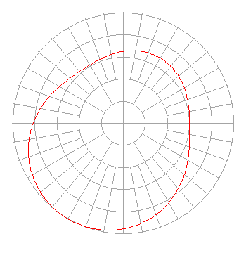
| Antenna Data for Antenna Id: 102966 WISH-TV LD File: BLCDT-20110207ACU Andrew - AL12-17-PL Service: LD Standard Pattern: Y Pattern and Field Values Include a 208° Clockwise Rotation |  | ||||||||||||||||||||||||||||||||||||||||||||||||||||||||||||||||||||||||
| Azimuth | Ratio | Azimuth | Ratio | Azimuth | Ratio | Azimuth | Ratio | ||||||||||||||||||||||||||||||||||||||||||||||||||||||||||||||||||
| 8 | 0.659 | 18 | 0.672 | 28 | 0.676 | 38 | 0.672 | ||||||||||||||||||||||||||||||||||||||||||||||||||||||||||||||||||
| 48 | 0.659 | 58 | 0.642 | 68 | 0.623 | 78 | 0.608 | ||||||||||||||||||||||||||||||||||||||||||||||||||||||||||||||||||
| 88 | 0.602 | 98 | 0.609 | 108 | 0.631 | 118 | 0.668 | ||||||||||||||||||||||||||||||||||||||||||||||||||||||||||||||||||
| 128 | 0.715 | 138 | 0.767 | 148 | 0.820 | 158 | 0.871 | ||||||||||||||||||||||||||||||||||||||||||||||||||||||||||||||||||
| 168 | 0.915 | 178 | 0.951 | 188 | 0.978 | 198 | 0.994 | ||||||||||||||||||||||||||||||||||||||||||||||||||||||||||||||||||
| 208 | 1.000 | 218 | 0.994 | 228 | 0.978 | 238 | 0.951 | ||||||||||||||||||||||||||||||||||||||||||||||||||||||||||||||||||
| 248 | 0.915 | 258 | 0.871 | 268 | 0.820 | 278 | 0.767 | ||||||||||||||||||||||||||||||||||||||||||||||||||||||||||||||||||
| 288 | 0.715 | 298 | 0.668 | 308 | 0.631 | 318 | 0.609 | ||||||||||||||||||||||||||||||||||||||||||||||||||||||||||||||||||
| 328 | 0.602 | 338 | 0.608 | 348 | 0.623 | 358 | 0.642 | ||||||||||||||||||||||||||||||||||||||||||||||||||||||||||||||||||
Structure Registration Number 1030817 Structure Type: TOWER Registered To: CCB License, LLC Structure Address: 7619 Walnut Dr Indianapolis, IN County Name: Marion County ASR Issued: 10/29/2019 Date Built: 12/31/1994 Site Elevation: 249.3 m (818 ft.) Structure Height: 275.5 m (904 ft.) Height Overall: 319.4 m (1048 ft.) Overall Height AMSL: 568.7 m (1866 ft.) FAA Determination: 05/06/1994 FAA Study #: 93-AGL-2149-OE FAA Circular #: 70/7460-1H Paint & Light FAA Chapters: 3, 4, 5, 13 39-53-25.0 N 86-12-20.0 W (NAD 83) 39-53-24.9 N 86-12-20.0 W (Converted to NAD 27) |
1950 N. Meridian Street Indianapolis, IN 46202 Phone: 317-956-8863 Limited Liability Company | Date: 02/07/2011 Application Certifier Indiana Broadcasting, LLC One West Exchange Street Suite 5A Providence, RI 02903-1058 Applicant George J Csahanin 908 West MLK Blvd Austin, TX 78701 Director of Engineering Parent Company Joshua N. Pila Lin Television Corporation | |||||||||||||||||||||||||||||||||||||||||||||||||||||||||||||||||||||||
|
| ||||||||||||||||||||||||||||||||||||||||||||||||||||||||||||||||||||||||