|
WUNF-TV
Call Sign History
WUNF-TV from 07/31/1978
WUNF from ???
|
Channel 25DT
Virtual Channel 33
| 
|
Asheville, NC
|
|
| WUNF-TV Service: DT - Digital TV | | Channel: 25 Zone: 2 |
| Asheville, North Carolina |
| Nielsen DMA™: Greenville - Spartanburg - Asheville - Anderson |
| Network: PBS |
| Virtual Channel: 33 |
| DTV TSID: 1785 |
| Facility ID: 69300 | | FRN: 0001910066 |
Status: LIC
Application Accepted: 04/01/2003
License Expires: 12/01/2028
File Number: BLEDT-20030401BAI
Prefix Type: This is a license for a noncommercial educational digital TV station
FCC Website Links:
LMS Facility Details
This Application
Other WUNF-TV Applications
Including Superseded Applications
Service Contour - Open Street Map or USGS Map (41 dBu)
Service Contour - KML / Google Earth (41 dBu)
Public Inspection Files
Rabbit Ears Info Search for WUNF-TV
Site Location: 35-25-32.0 N 82-45-24.0 W (NAD 83)
Site Location: 35-25-31.6 N 82-45-24.5 W (Converted to NAD 27)
ERP: 125 kW
Polarization: Horizontally polarized
HAAT: 816 m (2677 ft.)
Electrical Beam Tilt: 0.75 degrees
R/C AGL: 59 m (194 ft.)
R/C AMSL: 1802 m (5912 ft.)
Site Elevation: 1743 m. (5719 ft.)
Height Overall*: 103 m (338 ft.)
(* As Filed In This Application, may differ from ASR Data, Below.)
Directional Antenna - Antenna Make/Model: DIELECTRIC TFU-10DSC-RC170
Antenna ID: 87421
Polarization: Horizontally polarized
| Associated Translators |
| W20EK-D |
Ch. 20 | Andrews, Etc, North Carolina |
| W31DH-D |
Ch. 31 | Franklin, Etc, North Carolina |
| W31AN-D |
Ch. 31 | Murphy, North Carolina |
| W33EH-D |
Ch. 33 | Black Mountain, North Carolina |
| W28EE-D |
Ch. 28 | Canton, Etc., North Carolina |
| W19DB-D |
Ch. 19 | Franklin, North Carolina |
| W29DE-D |
Ch. 29 | Hayesville, North Carolina |
| W35CK-D |
Ch. 35 | Highlands, North Carolina |
|
Antenna Data for Antenna Id: 87421
WUNF-TV DT File: BLEDT-20030401BAI
DIELECTRIC - TFU-10DSC-RC170
Service: DT
Standard Pattern: Y
|
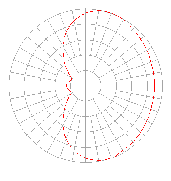 |
| Azimuth | Ratio | Azimuth | Ratio | Azimuth | Ratio | Azimuth | Ratio |
| 0 | 0.940 | 10 | 0.987 | 20 | 1.000 | 30 | 0.988 |
| 40 | 0.963 | 45 | 0.949 | 50 | 0.936 | 60 | 0.917 |
| 70 | 0.905 | 80 | 0.900 | 90 | 0.899 | 100 | 0.900 |
| 110 | 0.905 | 120 | 0.917 | 130 | 0.936 | 135 | 0.949 |
| 140 | 0.963 | 150 | 0.968 | 160 | 1.000 | 170 | 0.987 |
| 180 | 0.940 | 190 | 0.854 | 200 | 0.733 | 210 | 0.588 |
| 220 | 0.437 | 225 | 0.365 | 230 | 0.302 | 240 | 0.218 |
| 250 | 0.207 | 260 | 0.232 | 270 | 0.245 | 280 | 0.232 |
| 290 | 0.201 | 300 | 0.218 | 310 | 0.302 | 315 | 0.365 |
| 320 | 0.437 | 330 | 0.588 | 340 | 0.730 | 350 | 0.854 |
|
Structure Information
Structure Registration Number 1035173
Structure Type: TOWER
Registered To:
Sinclair Communications, LLC
Structure Address:
Top Of Mount Pisgah, Near Asheville
Canton, NC
County Name: Haywood County
ASR Issued: 01/11/2017
Date Built: 01/01/1954
Site Elevation: 1742.8 m (5718 ft.)
Structure Height: 102.3 m (336 ft.)
Height Overall: 103.2 m (339 ft.)
Overall Height AMSL: 1846 m (6056 ft.)
FAA Determination: 10/16/2008
FAA Study #: 2008-ASO-5728-OE
FAA Circular #: 70/7460-1K
Paint & Light FAA Chapters: 4, 8, 12
PRIOR STUDY 1977-ASO-1226-OE
35-25-32.0 N 82-45-24.0 W (NAD 83)
35-25-31.6 N 82-45-24.5 W
(Converted to NAD 27)
|
WUNF-TV Licensee Information
University of North Carolina
10 UNC-TV Drive
Research Triangle Park, NC 27709
Phone: 919-549-7000
Government Entity | 20030401BAI Applicant Information
Tom Howe
Date: 04/01/2003
Application Certifier
University of North Carolina
P.O. Box 14900
Research Triangle PA, NC 27709
Applicant
Wayne Estabrooks
P.O. Box 14900
Research Triangle PK, NC 27709
Chief Engineer - Transmission
Marcus W. Trathen
Brooks, Pierce Et. Al.
P.O. Box 1800
Raleigh, NC 27602
|
Associated Land Mobile Licenses
|
| (No Records Found) |
| Associated Microwave Licenses
|
| | WQIJ660 |
7 GHz TV Studio Transmitter Link |
|
