FCCInfo.com
A Service of Cavell, Mertz & Associates, Inc.
(855) FCC-INFO
|
|
|
|
|
|||||||||||||||||||
|
|
WHWC Channel: 202C1 88.3 MHz Menomonie, Wisconsin Service: FM - A full-service FM station or application. Facility ID: 63078 FRN: 0002711455 Fac. Service: FM Status: LIC Application Accepted: 02/18/2014 Application Granted: 02/28/2014 File Number: BMLED-20140218AAE License Expires: 12/01/2028 Prefix Type: This is a modification of license for a noncommercial educational FM station Application Type: Minor Modification FCC Website Links: LMS Facility Details This Application Other WHWC Applications Including Superseded Applications Service Contour - Open Street Map or USGS Map (60 dBu) Service Contour - KML / Google Earth (60 dBu) Public Inspection Files Facility Type: NON-COMMERCIAL EDUC. FM Class: C1, A Zone II station; with 50kW-100kW ERP and a class contour distance 52km-72km Site Location: 45-02-48.9 N 91-51-47.6 W (NAD 83) Site Location: 45-02-49.0 N 91-51-47.0 W (Converted to NAD 27) Effective Radiated Power: 71 kW Transmitter Output Power: 10.9 kW Antenna Center HAAT: 320 m (1050 ft.) Antenna Center AMSL: 625 m (2051 ft.) Antenna Center HAG: 327 m (1073 ft.) Calculated Site Elevation: 298 m. (978 ft.) Height Overall*: 366 m (1201 ft.) (* As Filed In This Application, may differ from ASR Data, Below.) Directional Antenna Antenna Make/Model: DIELECTRIC DCR-M8, eight sections Antenna ID: 15406 Polarization: | |||||||||||||||||||||
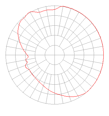
| Antenna Data for Antenna Id: 15406 WHWC FM File: BMLED-20140218AAE DIELECTRIC - DCR-M8, eight sections Service: FM |  | |||||||||||||||||||||
| Azimuth | Ratio | Azimuth | Ratio | Azimuth | Ratio | Azimuth | Ratio | |||||||||||||||
| 0 | 0.920 | 10 | 1.000 | 20 | 1.000 | 30 | 1.000 | |||||||||||||||
| 40 | 1.000 | 50 | 1.000 | 60 | 1.000 | 70 | 1.000 | |||||||||||||||
| 80 | 1.000 | 90 | 1.000 | 100 | 1.000 | 110 | 1.000 | |||||||||||||||
| 120 | 1.000 | 130 | 1.000 | 140 | 1.000 | 150 | 0.960 | |||||||||||||||
| 160 | 0.900 | 170 | 0.830 | 180 | 0.770 | 190 | 0.715 | |||||||||||||||
| 200 | 0.665 | 210 | 0.630 | 220 | 0.610 | 225 | 0.605 | |||||||||||||||
| 230 | 0.600 | 240 | 0.600 | 245 | 0.630 | 250 | 0.630 | |||||||||||||||
| 255 | 0.575 | 260 | 0.595 | 265 | 0.540 | 270 | 0.560 | |||||||||||||||
| 280 | 0.650 | 290 | 0.750 | 300 | 0.860 | 310 | 0.940 | |||||||||||||||
| 315 | 0.970 | 320 | 0.970 | 330 | 1.000 | 340 | 0.920 | |||||||||||||||
| 350 | 0.920 | |||||||||||||||||||||
Structure Registration Number 1035227 [ASR Heights Differ from WHWC Application] Structure Type: Registered To: State of Wisconsin - Educational Communications Board Structure Address: N10127 600th St Colfax, WI County Name: Dunn County ASR Issued: 10/12/2020 Date Built: 01/01/1973 Site Elevation: 298.7 m (980 ft.) Structure Height: 347.2 m (1139 ft.) Height Overall: 365.8 m (1200 ft.) Overall Height AMSL: 664.5 m (2180 ft.) FAA Determination: 12/12/2001 FAA Study #: 01-AGL-6431-OE FAA Circular #: 70/7460-1K Paint & Light FAA Chapters: 4, 7, 12 PRIOR STUDY 01-AGL-2462-OE 45-02-48.9 N 91-51-47.6 W (NAD 83) 45-02-49.0 N 91-51-47.0 W (Converted to NAD 27) |
3319 W. Beltline Hwy. Madison, WI 53713 Phone: 608-264-9600 Government Entity | Date: 02/18/2014 Application Certifier State of Wisconsin - Educational Communications Board 3319 W. Beltline Hwy. Madison, WI 53713 Applicant Glenn Guy 3319 W. Beltline Highway Madison, WI 53713 Staff Engineer Barry S. Persh Gray Miller Persh LLP | ||||||||||||||||||||
| ||||||||||||||||||||||