FCCInfo.com
A Service of Cavell, Mertz & Associates, Inc.
(855) FCC-INFO
|
|
|
|
|
||||||||||||||||
|
|
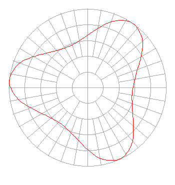
Status: LIC Application Accepted: 02/24/2014 License Expires: 08/01/2030 File Number: BLDTV-20140224AFM Prefix Type: This is BLDTV FCC Website Links: LMS Facility Details This Application Other K13ZQ-D Applications Including Superseded Applications Service Contour - Open Street Map or USGS Map (48 dBu) Service Contour - KML / Google Earth (48 dBu) Rabbit Ears Info Search for K13ZQ-D Site Location: 33-31-33.8 N 101-52-08.6 W (NAD 83) Site Location: 33-31-33.5 N 101-52-07.0 W (Converted to NAD 27) ERP: 3 kW R/C AGL: 130 m (427 ft.) R/C AMSL: 1114.2 m (3656 ft.) Emission Mask: Stringent Site Elevation: 984.2 m. (3229 ft.) Height Overall*: 279.5 m (917 ft.) (* As Filed In This Application, may differ from ASR Data, Below.) Directional Antenna - Antenna Make/Model: Kathrein DRV TRILOBE Antenna ID: 110014 | ||||||||||||||||||
| Antenna Data for Antenna Id: 110014 K13ZQ-D LD File: BLDTV-20140224AFM Kathrein - DRV TRILOBE Service: LD Standard Pattern: Y |  | ||||||||||||||||||
| Azimuth | Ratio | Azimuth | Ratio | Azimuth | Ratio | Azimuth | Ratio | ||||||||||||
| 0 | 0.662 | 10 | 0.761 | 20 | 0.889 | 30 | 0.976 | ||||||||||||
| 35 | 0.995 | 40 | 0.983 | 50 | 0.913 | 60 | 0.787 | ||||||||||||
| 70 | 0.677 | 80 | 0.613 | 90 | 0.578 | 100 | 0.574 | ||||||||||||
| 110 | 0.603 | 120 | 0.662 | 130 | 0.761 | 140 | 0.889 | ||||||||||||
| 150 | 0.976 | 155 | 0.995 | 160 | 0.983 | 170 | 0.913 | ||||||||||||
| 180 | 0.787 | 190 | 0.677 | 200 | 0.613 | 210 | 0.578 | ||||||||||||
| 220 | 0.574 | 230 | 0.603 | 240 | 0.662 | 250 | 0.761 | ||||||||||||
| 260 | 0.889 | 270 | 0.976 | 275 | 0.995 | 280 | 0.983 | ||||||||||||
| 290 | 0.913 | 300 | 0.787 | 310 | 0.677 | 320 | 0.613 | ||||||||||||
| 330 | 0.578 | 340 | 0.574 | 350 | 0.603 | ||||||||||||||
Structure Registration Number 1054347 Structure Type: GTOWER Registered To: American Towers LLC Structure Address: 2416 74th St (30483) Lubbock, TX County Name: Lubbock County ASR Issued: 12/10/2013 Date Built: 07/06/1998 Site Elevation: 984.2 m (3229 ft.) Structure Height: 255.1 m (837 ft.) Height Overall: 279.5 m (917 ft.) Overall Height AMSL: 1263.7 m (4146 ft.) FAA Determination: 12/05/2013 FAA Study #: 2013-ASW-7799-OE FAA Circular #: 70/7460-1K Paint & Light FAA Chapters: 3, 4, 5, 12 PRIOR STUDY 2011-ASW-2183-OE 33-31-33.8 N 101-52-08.6 W (NAD 83) 33-31-33.5 N 101-52-07.0 W (Converted to NAD 27) |
Baytown, TX 77520 Phone: 281-422-6644 Individual | Date: 02/24/2014 Application Certifier C. Dowen Johnson 104 Woodmont Montgomery, TX 77356 Applicant Jim McPhetridge 228 Flynn Drive. El Paso, TX 79932 Consulting Engineer James L. Oyster Law Offices of James L. Oyster | |||||||||||||||||