|
KXZZ(FM)
Call Sign History
KXZZ from 03/26/2024
KWEE from 10/05/2021
KTHX-FM from 02/10/1997
KZAK from 09/17/1990
KLKT from 03/01/1990
KZRK from 03/01/1990
|
100.1 MHz | 
|
Dayton, NV
|
|
KXZZ Channel: 261C1 100.1 MHz
Dayton, Nevada
Service: FM - A full-service FM station or application.
Facility ID: 48685
FRN: 0001595651
Fac. Service: FM
Status: LIC
73.215 Station
Application Accepted: 03/13/2002
Application Granted: 03/27/2002
File Number: BLH-20020313AAA
License Expires: 10/01/2029
Prefix Type: This is a license for a commercial FM station
Application Type: License To Cover
FCC Website Links:
LMS Facility Details
This Application
Other KXZZ Applications
Including Superseded Applications
Service Contour - Open Street Map or USGS Map (60 dBu)
Service Contour - KML / Google Earth (60 dBu)
Public Inspection Files
Facility Type: FM STATION
Class: C1, A Zone II station; with 50kW-100kW ERP and a class contour distance 52km-72km
Site Location: 39-15-33.7 N 119-42-24.6 W (NAD 83)
Site Location: 39-15-34.0 N 119-42-21.0 W (Converted to NAD 27)
Effective Radiated Power: 12 kW
Transmitter Output Power: 4.8 kW
Antenna Center HAAT: 659 m (2162 ft.)
Antenna Center AMSL: 2307 m (7569 ft.)
Antenna Center HAG: 55 m (180 ft.)
Site Elevation: 2252 m. (7388 ft.)
Height Overall*: 60.9 m (200 ft.)
(* As Filed In This Application, may differ from ASR Data, Below.)
Directional Antenna
Antenna Make/Model: Electronics Research Inc. MP-6E-DA-HW, 6 section, 0.5 wavelength spaced
Antenna ID: 42870
Polarization:
|
Antenna Data for Antenna Id: 42870
KXZZ FM File: BLH-20020313AAA
Electronics Research Inc. - MP-6E-DA-HW, 6 section, 0.5 wavelength spaced
Service: FM
|
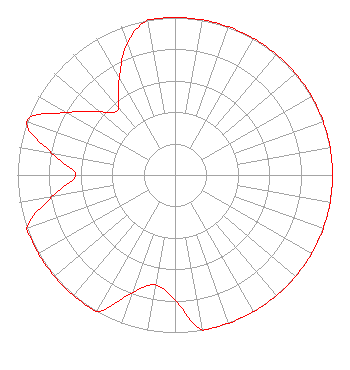 |
| Azimuth | Ratio | Azimuth | Ratio | Azimuth | Ratio | Azimuth | Ratio |
| 0 | 1.000 | 10 | 1.000 | 20 | 1.000 | 30 | 1.000 |
| 40 | 1.000 | 50 | 1.000 | 60 | 1.000 | 70 | 1.000 |
| 80 | 1.000 | 90 | 1.000 | 100 | 1.000 | 110 | 1.000 |
| 120 | 1.000 | 130 | 1.000 | 140 | 1.000 | 150 | 1.000 |
| 160 | 1.000 | 170 | 1.000 | 180 | 0.794 | 190 | 0.708 |
| 200 | 0.794 | 210 | 1.000 | 220 | 1.000 | 230 | 1.000 |
| 240 | 1.000 | 250 | 1.000 | 260 | 0.794 | 270 | 0.631 |
| 280 | 0.794 | 290 | 1.000 | 300 | 0.794 | 310 | 0.631 |
| 315 | 0.562 | 320 | 0.562 | 330 | 0.708 | 340 | 0.891 |
| 350 | 1.000 |
Structure Information
Structure Registration Number 1213938
Structure Type: GTOWER
Registered To:
American Towers LLC
Structure Address:
7705 Goni Road (209505)
Carson City, NV
County Name: Washoe County
ASR Issued: 08/05/2021
Date Built: 07/17/2001
Site Elevation: 2252.5 m (7390 ft.)
Structure Height: 60.9 m (200 ft.)
Height Overall: 60.9 m (200 ft.)
Overall Height AMSL: 2313.4 m (7590 ft.)
FAA Determination: 08/02/2021
FAA Study #: 2021-AWP-6675-OE
Paint & Light FAA Chapters: NONE
PRIOR STUDY 2000-AWP-1167-OE
39-15-32.8 N 119-42-23.9 W (NAD 83)
39-15-33.1 N 119-42-20.3 W
(Converted to NAD 27)
|
KXZZ(FM) Licensee Information
Lotus Radio Corp.
3301 Barham Boulevard
Los Angeles, CA 90068
Phone: 323-512-2225
| 20020313AAA Applicant Information
Matthew L. Leibowitz
Date: 03/13/2002
Application Certifier
NM Licensing, LLC
6312 South Fiddlers Green Cir.
Suite 360-E
Englewood, CO 80111
Applicant
Erik C. Swanson
Hatfield & Dawson Consulting Engineers
9500 Greenwood Ave N
Seattle, WA 98103
Joseph A. Belisle
Leibowitz & Associates
|
Associated Land Mobile Licenses
|
| | WPML279 |
Broadcast Auxiliary Remote Pickup |
| Associated Microwave Licenses
|
| | WMU742 |
950 MHz Aural Studio Transmitter Link |
|
