FCCInfo.com
A Service of Cavell, Mertz & Associates, Inc.
(855) FCC-INFO
|
|
WHIL-FM from 11/30/1978 WHILFM from ??? |
|  |
|
||||||||||||||||||
|
|
WHIL Channel: 217C 91.3 MHz Mobile, Alabama Service: FM - A full-service FM station or application. Facility ID: 61999 FRN: 0001749688 Fac. Service: FM Status: LIC Application Accepted: 07/28/1995 Application Granted: 11/29/1995 File Number: BLED-19950728KE License Expires: 04/01/2028 Prefix Type: This is a license for a noncommercial educational FM station Application Type: License To Cover FCC Website Links: LMS Facility Details This Application Other WHIL Applications Including Superseded Applications Service Contour - Open Street Map or USGS Map (60 dBu) Service Contour - KML / Google Earth (60 dBu) Public Inspection Files Facility Type: NON-COMMERCIAL EDUC. FM Class: C, A Zone II station; with exactly 100kW ERP and a class contour distance 72km-92km Site Location: 30-41-20.7 N 87-49-49.0 W (NAD 83) Site Location: 30-41-20.0 N 87-49-49.0 W (Converted to NAD 27) Effective Radiated Power: 100 kW Transmitter Output Power: 13 kW Antenna Center HAAT: 325 m (1066 ft.) Antenna Center AMSL: 356 m (1168 ft.) Antenna Center HAG: 304 m (997 ft.) Calculated Site Elevation: 52 m. (171 ft.) Height Overall*: 573 m (1880 ft.) (* As Filed In This Application, may differ from ASR Data, Below.) Directional Antenna Antenna Make/Model: Oddball; usually designed by Applicant ODD950607IB Antenna ID: 14802 Polarization: | |||||||||||||||||||||
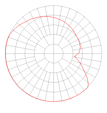
| Antenna Data for Antenna Id: 14802 WHIL FM File: BLED-19950728KE Oddball; usually designed by Applicant - ODD950607IB Service: FM |  | |||||||||||||||||||||
| Azimuth | Ratio | Azimuth | Ratio | Azimuth | Ratio | Azimuth | Ratio | |||||||||||||||
| 0 | 0.750 | 10 | 0.720 | 20 | 0.690 | 30 | 0.660 | |||||||||||||||
| 40 | 0.630 | 45 | 0.615 | 50 | 0.600 | 60 | 0.590 | |||||||||||||||
| 70 | 0.580 | 80 | 0.560 | 90 | 0.520 | 97 | 0.450 | |||||||||||||||
| 100 | 0.470 | 110 | 0.590 | 120 | 0.740 | 130 | 0.930 | |||||||||||||||
| 135 | 1.000 | 140 | 1.000 | 150 | 1.000 | 160 | 1.000 | |||||||||||||||
| 170 | 1.000 | 180 | 1.000 | 190 | 1.000 | 200 | 1.000 | |||||||||||||||
| 210 | 1.000 | 220 | 1.000 | 225 | 1.000 | 230 | 1.000 | |||||||||||||||
| 240 | 1.000 | 250 | 1.000 | 260 | 1.000 | 270 | 1.000 | |||||||||||||||
| 280 | 1.000 | 290 | 1.000 | 300 | 0.960 | 310 | 0.920 | |||||||||||||||
| 315 | 0.895 | 320 | 0.870 | 330 | 0.840 | 340 | 0.810 | |||||||||||||||
| 350 | 0.780 | |||||||||||||||||||||
Structure Registration Number 1035771 Structure Type: GTOWER Registered To: Nexstar Media Inc. Structure Address: 11400b Austin Lane Spanish Fort, AL County Name: Baldwin County ASR Issued: 05/28/2021 Date Built: 04/15/2015 Site Elevation: 51.8 m (170 ft.) Structure Height: 554.7 m (1820 ft.) Height Overall: 572.7 m (1879 ft.) Overall Height AMSL: 624.5 m (2049 ft.) FAA Determination: 04/15/2015 FAA Study #: 2015-ASO-644-OE Paint & Light FAA Chapters: A1, B, G, H Continue As Is OM&L = 24-HR HI-STROBES. PRIOR STUDY = 1984-ASO-1612-OE 30-41-20.4 N 87-49-50.6 W (NAD 83) 30-41-19.7 N 87-49-50.6 W (Converted to NAD 27) |
Box 870172 490 Reese Phifer Hall Tuscaloosa, AL 35487 Phone: 205-348-8657 Government Entity | Date: 07/28/1995 Application Certifier Spring Hill College Spring Hill College P O Box 8509 Mobile, AL 36689 Applicant | ||||||||||||||||||||
| ||||||||||||||||||||||