FCCInfo.com
A Service of Cavell, Mertz & Associates, Inc.
(855) FCC-INFO
|
|
|
Virtual Channel 13 |
|
||||||||||||||||||
|
|
Status: LIC Application Accepted: 09/03/2014 License Expires: 08/01/2030 File Number: BLEDT-20140903AFQ Prefix Type: This is a license for a noncommercial educational digital TV station FCC Website Links: LMS Facility Details This Application Other KERA-TV Applications Including Superseded Applications Service Contour - Open Street Map or USGS Map (41 dBu) Service Contour - KML / Google Earth (41 dBu) Public Inspection Files Rabbit Ears Info Search for KERA-TV Site Location: 32-32-36.0 N 96-57-33.0 W (NAD 83) Site Location: 32-32-35.5 N 96-57-32.0 W (Converted to NAD 27) ERP: 975 kW Polarization: Elliptically polarized HAAT: 514.4 m (1688 ft.) Electrical Beam Tilt: 0.75 degrees R/C AGL: 469.4 m (1540 ft.) R/C AMSL: 717.5 m (2354 ft.) Site Elevation: 248.1 m. (814 ft.) Height Overall*: 498.4 m (1635 ft.) (* As Filed In This Application, may differ from ASR Data, Below.) Directional Antenna - Antenna Make/Model: Electronics Research Inc. ATW21H3-ESC170-14H Antenna ID: 113863 Polarization: Elliptically polarized | ||||||||||||||||||||
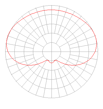
| Antenna Data for Antenna Id: 113863 KERA-TV DT File: BLEDT-20140903AFQ Electronics Research Inc. - ATW21H3-ESC170-14H Service: DT Standard Pattern: Y |  | ||||||||||||||||||||
| Azimuth | Ratio | Azimuth | Ratio | Azimuth | Ratio | Azimuth | Ratio | ||||||||||||||
| 0 | 0.899 | 10 | 0.900 | 20 | 0.905 | 30 | 0.917 | ||||||||||||||
| 40 | 0.936 | 50 | 0.963 | 60 | 0.988 | 70 | 1.000 | ||||||||||||||
| 80 | 0.987 | 90 | 0.940 | 100 | 0.854 | 110 | 0.733 | ||||||||||||||
| 120 | 0.588 | 130 | 0.437 | 140 | 0.302 | 150 | 0.218 | ||||||||||||||
| 160 | 0.207 | 170 | 0.232 | 180 | 0.245 | 190 | 0.232 | ||||||||||||||
| 200 | 0.207 | 210 | 0.218 | 220 | 0.302 | 230 | 0.437 | ||||||||||||||
| 240 | 0.588 | 250 | 0.733 | 260 | 0.854 | 270 | 0.940 | ||||||||||||||
| 280 | 0.987 | 290 | 1.000 | 300 | 0.988 | 310 | 0.963 | ||||||||||||||
| 320 | 0.936 | 330 | 0.917 | 340 | 0.905 | 350 | 0.900 | ||||||||||||||
Structure Registration Number 1059733 [ASR Heights Differ from KERA-TV Application] Structure Type: GTOWER Registered To: American Towers LLC Structure Address: 2133 Tar Rd (#282636) Cedar Hill, TX County Name: Ellis County ASR Issued: 04/03/2024 Date Built: 06/18/2000 Site Elevation: 247.8 m (813 ft.) Structure Height: 464.4 m (1524 ft.) Height Overall: 500.2 m (1641 ft.) Overall Height AMSL: 748 m (2454 ft.) FAA Determination: 04/10/2023 FAA Study #: 2022-ASW-23639-OE FAA Circular #: 70/7460-1M Paint & Light FAA Chapters: 4, 9, 15 PRIOR STUDY 2022-ASW-13327-OE 32-32-35.4 N 96-57-32.9 W (NAD 83) 32-32-34.9 N 96-57-31.9 W (Converted to NAD 27) |
1516 First Ave. Dallas, TX 75210 Phone: 214-740-9377 Not-for-Profit | Date: 09/03/2014 Application Certifier North Texas Public Broadcasting, Inc. 3000 Harry Hines Blvd Dallas, TX 75201-1012 Applicant David Sanderford PO Box 485 6100 S Interstate 35W Alvarado, TX 76009-0485 Project Engineer William S. Leftwich North Texas Public Broadcasting, Inc. | |||||||||||||||||||