|
WFUV Channel: 214B 90.7 MHz
New York, New York
Service: FS - A full service FM station auxiliary transmitting antenna or application.
Facility ID: 22033
FRN: 0003483310
Fac. Service: FM Analog & Digital
Status: LIC
Application Accepted: 03/27/2006
Application Granted: 03/30/2006
File Number: BXLED-20060327AFC
License Expires: 06/01/2030
Prefix Type: This is BXLED
Application Type: License To Cover
FCC Website Links:
LMS Facility Details
This Application
Other WFUV Applications
Including Superseded Applications
Service Contour - Open Street Map or USGS Map (60 dBu)
Service Contour - KML / Google Earth (60 dBu)
Public Inspection Files
Facility Type: NON-COMMERCIAL EDUC. FM
Class: B, A Zone I or I-A station; with 25kW-50kW ERP and a class contour distance 39km-52km
Site Location: 40-52-48.4 N 73-52-38.5 W (NAD 83)
Site Location: 40-52-48.0 N 73-52-40.0 W (Converted to NAD 27)
Effective Radiated Power: 23 kW
Transmitter Output Power: 14.1 kW
Antenna Center HAAT: 142 m (466 ft.)
Antenna Center AMSL: 166.8 m (547 ft.)
Antenna Center HAG: 111.9 m (367 ft.)
Site Elevation: 54.9 m. (180 ft.)
Height Overall*: 134.1 m (440 ft.)
(* As Filed In This Application, may differ from ASR Data, Below.)
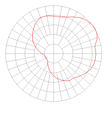
Directional Antenna
Antenna Make/Model: DIELECTRIC DCRM2E5H
Antenna ID: 71762
Polarization:
| Associated Translators |
| WFUV-FM3 |
Ch. 214 | New York, New York |
|
Structure Information
Structure Registration Number 1247379
Structure Type: BTWR
Registered To:
Fordham University
Structure Address:
3450 Wayne Avenue
Bronx, NY
County Name: Bronx County
ASR Issued: 09/26/2012
Date Built: 09/25/2005
Site Elevation: 54.9 m (180 ft.)
Structure Height: 133.2 m (437 ft.)
Height Overall: 134.1 m (440 ft.)
Overall Height AMSL: 189 m (620 ft.)
FAA Determination: 05/25/2005
FAA Study #: 2005-aea-1759-oe
FAA Circular #: 70/7460-1K
Paint & Light FAA Chapters: 4, 8, 12
Removed expiration date from determination. Scenario 1./jjs/case#635066
40-52-48.4 N 73-52-38.5 W (NAD 83)
40-52-48.0 N 73-52-40.0 W
(Converted to NAD 27)
|
WFUV(FM) Licensee Information
Fordham University
441 E. Fordham Road
Bronx, NY 10458
Phone: 718-817-4560
Fax: 718-365-9815
Private Not-for-Profit Educational Institution | 20060327AFC Applicant Information
Brian J. Byrne
Date: 03/27/2006
Application Certifier
Fordham University
441 E. Fordham Rd.
Bronx, NY 10458-9993
Applicant
Clarence M. Beverage
Communications Technologies, Inc.
P.O. Box 1130
Marlton, NJ 08053
Broadcast Engineering Consultant
Margot Polivy, Esq.
Renouf & Polivy
|